IMAGES TAKEN NEAR TO
Edmund Grove, FELTHAM, TW13 5QR
Introduction
This page details the photographs taken nearby to Edmund Grove, TW13 5QR by members of the Geograph project.
The Geograph project started in 2005 with the aim of publishing, organising and preserving representative images for every square kilometre of Great Britain, Ireland and the Isle of Man.

There are currently over 7.5m images from over14,400 individuals and you can help contribute to the project by visiting https://www.geograph.org.uk
Image Map
Images are licensed for reuse under creativecommons.org/licenses/by-sa/2.0
Notes
- Clicking on the map will re-center to the selected point.
- The higher the marker number, the further away the image location is from the centre of the postcode.
Image Listing (46 Images Found)
Images are licensed for reuse under creativecommons.org/licenses/by-sa/2.0
Image
Details
Distance
1
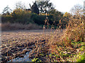
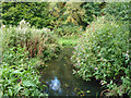
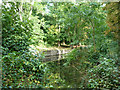
Reed Bed, Crane Park Island
Shown as open water on the map, the middle of Crane Park Island is now more of a marsh. It was probably an old millpond at one time.
Some of the reeds have been cut, maybe as habitat enhancement? The island is a nature reserve.
Image: © Des Blenkinsopp
Taken: 13 Nov 2011
0.05 miles
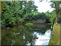
2
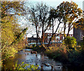
River Crane, Crane Park Island
The south side of Crane Park Island nature reserve, the edge of Crane Park and a London borough boundary, Richmond on the left, Hounslow on the right.
Image: © Des Blenkinsopp
Taken: 13 Nov 2011
0.06 miles
3
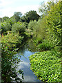
Former mill pond, Hounslow Powder Mills site
With level much reduced, the large pond is now a marsh with channels leading to an old sluice (the viewpoint) and, out of sight to the left, to a former mill race.
Image: © Robin Webster
Taken: 14 Sep 2012
0.08 miles
4
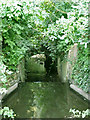
Old mill race, Hounslow Powder Mills site
Viewed from upstream, from a position that was probably under water when the mill pond was in operational condition. This is by interpretative station 3, according to a nearby post, but a corresponding on-line description does not seem to exist.
Image: © Robin Webster
Taken: 14 Sep 2012
0.08 miles
5
Crane Park at the powder mills site
This is a channel in the bed of an old mill pond, just upstream of where one of the lower powder mills was. The Hounslow Powder Mills had a complex layout of mills and associated waterways. This was a large pond once, but has become silted and overgrown.
Image: © Robin Webster
Taken: 14 Sep 2012
0.09 miles
6
River Crane below old sluice
On the site of the old Hounslow Powder Mills.
Image: © Robin Webster
Taken: 14 Sep 2012
0.09 miles
7
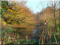
The Mill Stream, Crane Park
This is the channel that once took the River Crane to the wheels of the old gunpowder mills which operated here until 1927. http://www.oldindustry.org/ShotTowers/local_history_river_crane.pdf
The wheels are long gone, but the sluices are still visible. The millstream is now silted and overgrown as you see, but is no doubt a very good habitat. It's part of Crane Park Island nature reserve.
Most of the river flow now goes down the channel to the south of the island.
Image: © Des Blenkinsopp
Taken: 13 Nov 2011
0.09 miles
8
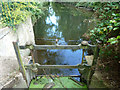
Old sluice, Hounslow Powder Mills site
Much of the device is missing. Details of the manufacturer are cast on what remains: 'Fredk. Bird & Co Engineers 11 Gt. Castle St. Regent St. London'. This address, and another seen mentioned for this company close by in Marlborough Mews, are very close to Oxford Circus. No maps suggest that if there was any works here that it was any bigger than a shop, so the addresses are probably for their sales offices. A further address seen mentioned for this company was at West Drayton. This seems more likely to be their works.
Image: © Robin Webster
Taken: 14 Sep 2012
0.10 miles
9
Looking across the park to Nene Gardens
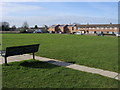
From Saxon Avenue looking across the park to Nene Gardens
Image: © Shaun Ferguson
Taken: 15 Feb 2013
0.10 miles
10
Crane Park at the powder mills site
This is the mill race downstream of where one of the lower powder mills was. The Hounslow Powder Mills had a complex layout of mills and associated waterways. Not all of the waterways are still present, but this one seems to have been associated with a mill at the camera position, and also with a mill which discharged through a channel just behind the large trees. This second channel has been filled in.
Image: © Robin Webster
Taken: 14 Sep 2012
0.10 miles