IMAGES TAKEN NEAR TO
Sunningdale Avenue, FELTHAM, TW13 5JS
Introduction
This page details the photographs taken nearby to Sunningdale Avenue, TW13 5JS by members of the Geograph project.
The Geograph project started in 2005 with the aim of publishing, organising and preserving representative images for every square kilometre of Great Britain, Ireland and the Isle of Man.

There are currently over 7.5m images from over14,400 individuals and you can help contribute to the project by visiting https://www.geograph.org.uk
Image Map
Images are licensed for reuse under creativecommons.org/licenses/by-sa/2.0
Notes
- Clicking on the map will re-center to the selected point.
- The higher the marker number, the further away the image location is from the centre of the postcode.
Image Listing (39 Images Found)
Images are licensed for reuse under creativecommons.org/licenses/by-sa/2.0
Image
Details
Distance
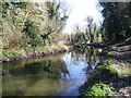
2
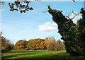
Dead Tree with Ivy
Probably not the safest place to shelter in a storm.....
This is the eastern end of Pevensey Road nature reserve, a continuation of the public access park and woodland which follows the course of the River Crane. http://www.kidsfunlondon.co.uk/kids-london/park/pevensey-road-open-space-and-nature-reserve.html
Image: © Des Blenkinsopp
Taken: 25 Nov 2011
0.12 miles
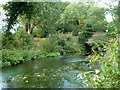
5
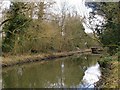
River Crane near Hanworth Road
Crane Park is an attractive linear park following the River Crane in the Boroughs of Hounslow and Richmond upon Thames. This view is immediately downriver of Hanworth Road and here the river is split in two - this is the southern channel. The London LOOP, which passes through much of Crane Park is to the north of the northern channel.
Image: © Marathon
Taken: 28 Mar 2012
0.18 miles
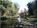
6
River Crane below A314 bridge
This is just above the site of the old Hounslow Powder Mills. The leat for its upper mills also passes under the road, but at a higher level, somewhat to the right of this view.
Image: © Robin Webster
Taken: 14 Sep 2012
0.18 miles
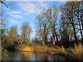
7
River Crane in Crane Park
Crane Park is an attractive linear park following the River Crane in the Boroughs of Hounslow and Richmond upon Thames. This view is immediately downriver of Hanworth Road and here the river is split in two - this is the southern channel. The London LOOP, which passes through much of Crane Park is to the north of the northern channel.
Image: © Marathon
Taken: 28 Mar 2012
0.18 miles
8
Northwestern end of Crane Park
Crane Park Island Nature Reserve is located in the Twickenham area and offers a peaceful haven for wildlife amid London’s suburbia. The island is man-made and is 4.5 acres in size. It is connected to the “mainland” by a short crossing through a gate and a walkway overlooking the river. The site was formerly the location of the Hounslow Gunpowder Mills. The mills used the River Crane as a source of water power.
Image: © Peter S
Taken: 29 Dec 2015
0.19 miles
9
The River Crane: view downstream towards the Hanworth Road bridge
Seen from the Pevensey Road nature reserve.
Image: © Stefan Czapski
Taken: 12 Mar 2013
0.19 miles
10
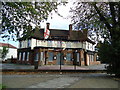
Horse & Groom public house, Hanworth
Image: © Stacey Harris
Taken: 16 Oct 2010
0.19 miles