IMAGES TAKEN NEAR TO
Wigley Road, FELTHAM, TW13 5HF
Introduction
This page details the photographs taken nearby to Wigley Road, TW13 5HF by members of the Geograph project.
The Geograph project started in 2005 with the aim of publishing, organising and preserving representative images for every square kilometre of Great Britain, Ireland and the Isle of Man.

There are currently over 7.5m images from over14,400 individuals and you can help contribute to the project by visiting https://www.geograph.org.uk
Image Map
Images are licensed for reuse under creativecommons.org/licenses/by-sa/2.0
Notes
- Clicking on the map will re-center to the selected point.
- The higher the marker number, the further away the image location is from the centre of the postcode.
Image Listing (15 Images Found)
Images are licensed for reuse under creativecommons.org/licenses/by-sa/2.0
Image
Details
Distance
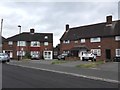
2
Eastbourne Road Junction with Westbury Road
Image: © James Emmans
Taken: 22 Aug 2016
0.08 miles
3
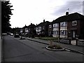
Pevensey Road
Opposite Pevensey Road Nature Reserve. The road traffic calming bollards have a small garden in each.
Image: © James Emmans
Taken: 22 Aug 2016
0.12 miles
4
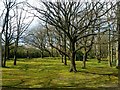
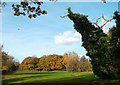
Wooded area at South West Middlesex Crematorium
Part of the peaceful grounds of remembrance.
See; http://www.swmcrematorium.gov.uk/
Image: © Jonathan Billinger
Taken: 5 Apr 2016
0.12 miles
5
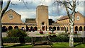
South West Middlesex Crematorium
The first photo of this building for Geograph since the very first for the square in September 2005; Image
See; http://www.swmcrematorium.gov.uk/
Image: © Jonathan Billinger
Taken: 5 Apr 2016
0.15 miles
6
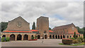
South West Middlesex Crematorium
Main building built in 1954.
I've geographed here before, see Image
Image: © Jonathan Billinger
Taken: 2 Sep 2021
0.15 miles
7
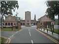
South West Middlesex Crematorium
Opened in 1954.
Image: © Martin Elliff
Taken: 23 Sep 2005
0.15 miles
8
Dead Tree with Ivy
Probably not the safest place to shelter in a storm.....
This is the eastern end of Pevensey Road nature reserve, a continuation of the public access park and woodland which follows the course of the River Crane. http://www.kidsfunlondon.co.uk/kids-london/park/pevensey-road-open-space-and-nature-reserve.html
Image: © Des Blenkinsopp
Taken: 25 Nov 2011
0.23 miles
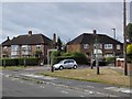
9

Feltham: Open space north of Uxbridge Road
The buildings on the left form part of West Thames College while the houses to the right are on Wigley Road. The last vestiges of the snow of 2 February 2009 can be seen on the ground to the left.
Image: © Nigel Cox
Taken: 8 Feb 2009
0.23 miles
10
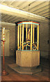
All Saints, Uxbridge Road, Hanworth - Font
Image: © John Salmon
Taken: 10 Dec 2004
0.25 miles