IMAGES TAKEN NEAR TO
Wigley Road, FELTHAM, TW13 5HD
Introduction
This page details the photographs taken nearby to Wigley Road, TW13 5HD by members of the Geograph project.
The Geograph project started in 2005 with the aim of publishing, organising and preserving representative images for every square kilometre of Great Britain, Ireland and the Isle of Man.

There are currently over 7.5m images from over14,400 individuals and you can help contribute to the project by visiting https://www.geograph.org.uk
Image Map
Images are licensed for reuse under creativecommons.org/licenses/by-sa/2.0
Notes
- Clicking on the map will re-center to the selected point.
- The higher the marker number, the further away the image location is from the centre of the postcode.
Image Listing (19 Images Found)
Images are licensed for reuse under creativecommons.org/licenses/by-sa/2.0
Image
Details
Distance
1

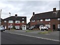
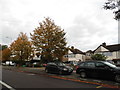
Feltham: Open space north of Uxbridge Road
The buildings on the left form part of West Thames College while the houses to the right are on Wigley Road. The last vestiges of the snow of 2 February 2009 can be seen on the ground to the left.
Image: © Nigel Cox
Taken: 8 Feb 2009
0.11 miles
3
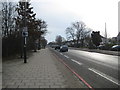
Feltham: A312 Uxbridge Road
The red line at the side of the road indicates that this is a Red Route Urban Clearway with no stopping permitted Monday to Saturday between 7am and 7pm.
Image: © Nigel Cox
Taken: 8 Feb 2009
0.15 miles
4
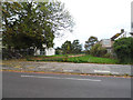
The entrance to Hanworth Park on Uxbridge Road
Image: © David Howard
Taken: 21 Oct 2013
0.16 miles
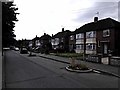
5
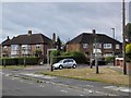
Eastbourne Road Junction with Westbury Road
Image: © James Emmans
Taken: 22 Aug 2016
0.17 miles
7
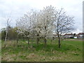
Springtime in Hanworth Park
Hanworth Park House was built between 1802 and 1835 as a replacement for the manor house that had served as a hunting lodge for, among others, Henry VII, Henry VIII and Queen Elizabeth I. It was used as a military hospital during the First World War, as a flying club between the wars, a hotel from 1936 to 1953 and an old people's home from 1953 to 1992 when it closed. Hanworth Park House is now fenced off and semi-derelict. The park was used as a grass airfield between 1917 and 1919, and 1929 and 1947. In the 1930s, it was best known as a centre for private flying, society events, visits by the Graf Zeppelin airship, and for aircraft manufacture by General Aircraft Limited (GAL) 1934-1949. In 1946, Heathrow came into use as the principal London Airport, and for several years flights at Hanworth were subject to Heathrow air traffic clearance, eventually growing to delays of several hours so that no fixed-wing flights were recorded after 1955. In 1956, Feltham Urban District Council purchased Hanworth Park. The Longford River was partly culverted and covered to permit aircraft to taxi over it. This view of Hanworth Park looks towards the back of the houses in Uxbridge Road.
Image: © Marathon
Taken: 4 Apr 2012
0.21 miles
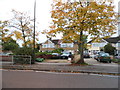
8
Pevensey Road
Opposite Pevensey Road Nature Reserve. The road traffic calming bollards have a small garden in each.
Image: © James Emmans
Taken: 22 Aug 2016
0.22 miles
10
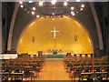
All Saints, Uxbridge Road, Hanworth - East end
Image: © John Salmon
Taken: 10 Dec 2004
0.23 miles