IMAGES TAKEN NEAR TO
Danesbury Road, FELTHAM, TW13 5BH
Introduction
This page details the photographs taken nearby to Danesbury Road, TW13 5BH by members of the Geograph project.
The Geograph project started in 2005 with the aim of publishing, organising and preserving representative images for every square kilometre of Great Britain, Ireland and the Isle of Man.

There are currently over 7.5m images from over14,400 individuals and you can help contribute to the project by visiting https://www.geograph.org.uk
Image Map
Images are licensed for reuse under creativecommons.org/licenses/by-sa/2.0
Notes
- Clicking on the map will re-center to the selected point.
- The higher the marker number, the further away the image location is from the centre of the postcode.
Image Listing (47 Images Found)
Images are licensed for reuse under creativecommons.org/licenses/by-sa/2.0
Image
Details
Distance
1
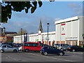
Leisure West, Feltham
Cinema, ten pin bowling and large area of car parking near to Feltham High Street.
Image: © Colin Smith
Taken: 6 Nov 2007
0.07 miles
2
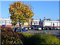
Leisure West Sprawl
Wide expanse of modern entertainment and restaurant facilities between Feltham High Street and Business Park.
Image: © Colin Smith
Taken: 6 Nov 2007
0.08 miles
3
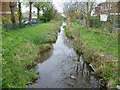
The Longford River in the centre of Feltham
The Longford River was constructed in 1638 to take water from the River Colne. This would then supplement the water supply to Hampton Court and enable the development of the water features in the park. Here the Longford River is viewed from the High Street in the centre of Feltham as it heads towards Hanworth Park.
Image: © Marathon
Taken: 4 Apr 2012
0.10 miles
4
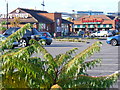
Feltham Fare
Fast food restaurants in the Leisure West complex which also has a cinema and ten pin bowling complex.
Image: © Colin Smith
Taken: 6 Nov 2007
0.12 miles
5
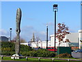
Propeller Sculpture
Located on the site of the former Hanworth Air Park WW2 fighters were made and repaired. The air park was closed in 1946 and today it is occupied by leisure facilities and warehousing. The steeple on the skyline is the former St Catherine's church.
Image: © Colin Smith
Taken: 6 Nov 2007
0.12 miles
6
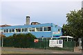
Feltham Community College
This is the old original part of what is now a very large school to the left.
Image: © David Howard
Taken: 16 Aug 2018
0.13 miles
7
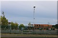
Feltham Community College
Various schools share this site.
Image: © David Howard
Taken: 16 Aug 2018
0.14 miles
8
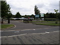
Feltham Community School sports complex
Feltham Community School sports complex on Browells Lane
Image: © Shaun Ferguson
Taken: 17 Jul 2008
0.15 miles
9
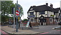
The Airman, Feltham
Mock Tudor building in the angle of the Hanworth and Harlington Roads.
Image: © Jonathan Billinger
Taken: 5 Jul 2015
0.16 miles
10
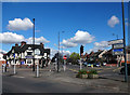
The Airman Public House
The Airman pub, viewed from Hanworth Road, with Harlington Road East running to the right of the building.
Image: © Peter Kazmierczak
Taken: 17 Apr 2016
0.16 miles