IMAGES TAKEN NEAR TO
Hamilton Road, FELTHAM, TW13 4PR
Introduction
This page details the photographs taken nearby to Hamilton Road, TW13 4PR by members of the Geograph project.
The Geograph project started in 2005 with the aim of publishing, organising and preserving representative images for every square kilometre of Great Britain, Ireland and the Isle of Man.

There are currently over 7.5m images from over14,400 individuals and you can help contribute to the project by visiting https://www.geograph.org.uk
Image Map
Images are licensed for reuse under creativecommons.org/licenses/by-sa/2.0
Notes
- Clicking on the map will re-center to the selected point.
- The higher the marker number, the further away the image location is from the centre of the postcode.
Image Listing (10 Images Found)
Images are licensed for reuse under creativecommons.org/licenses/by-sa/2.0
Image
Details
Distance
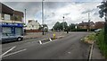
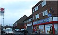
1
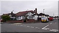
Hamilton Road junction with Denison Road - Lower Feltham
Image: © James Emmans
Taken: 16 Apr 2016
0.13 miles
2
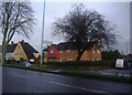
Chertsey Road Feltham
At junction of Cranleigh Road
Image: © David Howard
Taken: 27 Feb 2011
0.15 miles
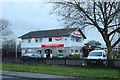
3
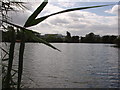
Lakeside in Sunbury
This is a nature reserve in Sunbury near the BP estate
Image: © steve
Taken: 19 Jul 2005
0.15 miles
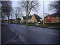
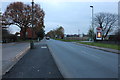
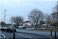
5
North end of Vicarage Road
Roundabout leading to Sunbury Road, Snakey Lane and Hamilton Road.
Image: © James Emmans
Taken: 8 Aug 2021
0.21 miles
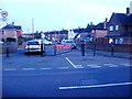
10
Groveley Road, Lower Feltham
Looking towards the Running Horse pub
Image: © David Howard
Taken: 26 Nov 2018
0.24 miles