IMAGES TAKEN NEAR TO
Bedfont Road, FELTHAM, TW13 4ND
Introduction
This page details the photographs taken nearby to Bedfont Road, TW13 4ND by members of the Geograph project.
The Geograph project started in 2005 with the aim of publishing, organising and preserving representative images for every square kilometre of Great Britain, Ireland and the Isle of Man.

There are currently over 7.5m images from over14,400 individuals and you can help contribute to the project by visiting https://www.geograph.org.uk
Image Map
Images are licensed for reuse under creativecommons.org/licenses/by-sa/2.0
Notes
- Clicking on the map will re-center to the selected point.
- The higher the marker number, the further away the image location is from the centre of the postcode.
Image Listing (21 Images Found)
Images are licensed for reuse under creativecommons.org/licenses/by-sa/2.0
Image
Details
Distance
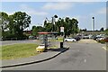
1

Car park at Feltham Young Offendors Institute
This is the main Borstal for the London area, the original one being in Kent near Maidstone.
Image: © David Howard
Taken: 26 Oct 2014
0.03 miles
4
Entrance to Feltham Young Offenders Prison
Image: © N Chadwick
Taken: 7 Jun 2023
0.07 miles