IMAGES TAKEN NEAR TO
Raleigh Road, FELTHAM, TW13 4LW
Introduction
This page details the photographs taken nearby to Raleigh Road, TW13 4LW by members of the Geograph project.
The Geograph project started in 2005 with the aim of publishing, organising and preserving representative images for every square kilometre of Great Britain, Ireland and the Isle of Man.

There are currently over 7.5m images from over14,400 individuals and you can help contribute to the project by visiting https://www.geograph.org.uk
Image Map
Images are licensed for reuse under creativecommons.org/licenses/by-sa/2.0
Notes
- Clicking on the map will re-center to the selected point.
- The higher the marker number, the further away the image location is from the centre of the postcode.
Image Listing (14 Images Found)
Images are licensed for reuse under creativecommons.org/licenses/by-sa/2.0
Image
Details
Distance
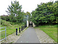
4
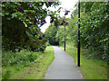
Path beside railway, Feltham
The railway is on the right.
Image: © Robin Webster
Taken: 12 Aug 2017
0.13 miles
5
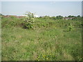
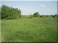
View across Bedfont Pits
Bedfont Pits is an area of old gravel workings to the north of the railway line from Feltham to Ashford, and Bedfont Road. It is fairly freely accessible and consists of mounds and troughs, all covered by fairly dense vegetation. This view looks across Bedfont Pits towards Feltham.
Image: © Marathon
Taken: 4 May 2011
0.13 miles
6
Bedfont Pits
Bedfont Pits is an area of old gravel workings to the north of the railway line from Feltham to Ashford, and Bedfont Road. It is fairly freely accessible and consists of mounds and troughs, all covered by fairly dense vegetation as seen here.
Image: © Marathon
Taken: 4 May 2011
0.16 miles
7
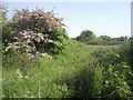
Bedfont Pits
Bedfont Pits is an area of old gravel workings to the north of the railway line from Feltham to Ashford, and Bedfont Road. It is fairly freely accessible and consists of mounds and troughs, all covered by fairly dense vegetation. This view looks towards the houses of Ambleside Drive with an ever present plane taking off from Heathrow in the background.
Image: © Marathon
Taken: 4 May 2011
0.17 miles
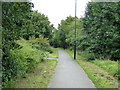
8
Path beside railway, Feltham
The railway is on the right.
Image: © Robin Webster
Taken: 12 Aug 2017
0.19 miles
9
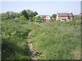
Looking across Bedfont Pits
Bedfont Pits is an area of old gravel workings to the north of the railway line from Feltham to Ashford, and Bedfont Road. It is fairly freely accessible and consists of mounds and troughs, all covered by fairly dense vegetation. This view looks towards Feltham.
Image: © Marathon
Taken: 4 May 2011
0.21 miles
10
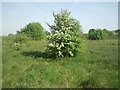
Hawthorn on Bedfont Pits
Bedfont Pits is an area of old gravel workings to the north of the railway line from Feltham to Ashford, and Bedfont Road. It is fairly freely accessible and consists of mounds and troughs, all covered by fairly dense vegetation. This view looks towards Feltham.
Image: © Marathon
Taken: 4 May 2011
0.22 miles