IMAGES TAKEN NEAR TO
Raleigh Road, FELTHAM, TW13 4LR
Introduction
This page details the photographs taken nearby to Raleigh Road, TW13 4LR by members of the Geograph project.
The Geograph project started in 2005 with the aim of publishing, organising and preserving representative images for every square kilometre of Great Britain, Ireland and the Isle of Man.

There are currently over 7.5m images from over14,400 individuals and you can help contribute to the project by visiting https://www.geograph.org.uk
Image Map
Images are licensed for reuse under creativecommons.org/licenses/by-sa/2.0
Notes
- Clicking on the map will re-center to the selected point.
- The higher the marker number, the further away the image location is from the centre of the postcode.
Image Listing (25 Images Found)
Images are licensed for reuse under creativecommons.org/licenses/by-sa/2.0
Image
Details
Distance
1
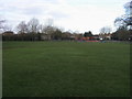
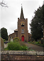
St Dunstans Park
From St Dunstans Road looking to St Dunstans Park
Image: © Shaun Ferguson
Taken: 15 Feb 2013
0.16 miles
3
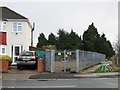
Elveden Road
An entrance from Chertsey Road to a labyrinthine housing development.
Image: © Robin Webster
Taken: 12 Aug 2017
0.18 miles
5

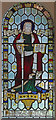
St Dunstan, Lower Feltham - Stained glass window
Image: © John Salmon
Taken: 20 Mar 2017
0.21 miles
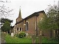
6
St Dunstan, Lower Feltham - Stained glass window
Image: © John Salmon
Taken: 20 Mar 2017
0.21 miles
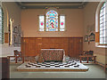
10
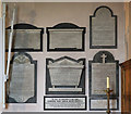
St Dunstan, Lower Feltham - Wall monuments
Image: © John Salmon
Taken: 20 Mar 2017
0.22 miles