IMAGES TAKEN NEAR TO
Rose Gardens, FELTHAM, TW13 4JE
Introduction
This page details the photographs taken nearby to Rose Gardens, TW13 4JE by members of the Geograph project.
The Geograph project started in 2005 with the aim of publishing, organising and preserving representative images for every square kilometre of Great Britain, Ireland and the Isle of Man.

There are currently over 7.5m images from over14,400 individuals and you can help contribute to the project by visiting https://www.geograph.org.uk
Image Map
Images are licensed for reuse under creativecommons.org/licenses/by-sa/2.0
Notes
- Clicking on the map will re-center to the selected point.
- The higher the marker number, the further away the image location is from the centre of the postcode.
Image Listing (6 Images Found)
Images are licensed for reuse under creativecommons.org/licenses/by-sa/2.0
Image
Details
Distance
4
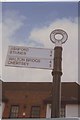
Old Direction Sign - Signpost High Street, Lower Feltham, Feltham Parish
Halo finial - 2 arms; Middlesex Parish halo by the A244, in parish of Feltham (Hounslow District), High Street, junction with St Dunstan's Road on William Smith Green, most is replacement.
Surveyed
Milestone Society National ID: MX_TQ0972
Image: © Milestone Society
Taken: Unknown
0.22 miles
5
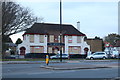
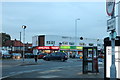
No longer The Mansion pub, Feltham
Apparently many pub owners are deliberately running down the business so they can close them down and sell them for great profits for housing developments. But the field is not shrinking as they are being replaced by fewer but far larger pubs instead.
Image: © David Howard
Taken: 26 Nov 2018
0.23 miles
6
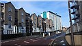
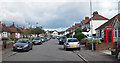
Housing in Highfield Road and Tilley Road
Image: © James Emmans
Taken: 14 Feb 2016
0.24 miles