IMAGES TAKEN NEAR TO
Bedfont Lane, FELTHAM, TW13 4GB
Introduction
This page details the photographs taken nearby to Bedfont Lane, TW13 4GB by members of the Geograph project.
The Geograph project started in 2005 with the aim of publishing, organising and preserving representative images for every square kilometre of Great Britain, Ireland and the Isle of Man.

There are currently over 7.5m images from over14,400 individuals and you can help contribute to the project by visiting https://www.geograph.org.uk
Image Map
Images are licensed for reuse under creativecommons.org/licenses/by-sa/2.0
Notes
- Clicking on the map will re-center to the selected point.
- The higher the marker number, the further away the image location is from the centre of the postcode.
Image Listing (92 Images Found)
Images are licensed for reuse under creativecommons.org/licenses/by-sa/2.0
Image
Details
Distance

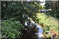
2
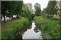
Longford River
Viewed from High Street in Feltham.
Image: © Bill Boaden
Taken: 26 May 2022
0.03 miles
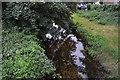
4
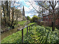
Sylvan scene in Feltham
Right in the middle of Feltham, behind the railway station, is this quiet spot by the Longford River.
Image: © Peter Kazmierczak
Taken: 17 Apr 2016
0.04 miles
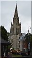
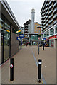
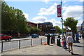
10
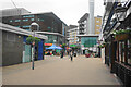
The Centre, Feltham
A shopping mall in the centre of Feltham.
Image: © Bill Boaden
Taken: 26 May 2022
0.05 miles