IMAGES TAKEN NEAR TO
Manor Lane, FELTHAM, TW13 4FE
Introduction
This page details the photographs taken nearby to Manor Lane, TW13 4FE by members of the Geograph project.
The Geograph project started in 2005 with the aim of publishing, organising and preserving representative images for every square kilometre of Great Britain, Ireland and the Isle of Man.

There are currently over 7.5m images from over14,400 individuals and you can help contribute to the project by visiting https://www.geograph.org.uk
Image Map
Images are licensed for reuse under creativecommons.org/licenses/by-sa/2.0
Notes
- Clicking on the map will re-center to the selected point.
- The higher the marker number, the further away the image location is from the centre of the postcode.
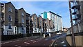
Image Listing (5 Images Found)
Images are licensed for reuse under creativecommons.org/licenses/by-sa/2.0
Image
Details
Distance
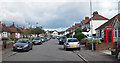
1
Housing in Highfield Road and Tilley Road
Image: © James Emmans
Taken: 14 Feb 2016
0.19 miles
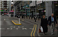
3
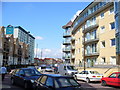
Highfield Road, Feltham
Changes in Feltham, by the new shopping centre. New flats and a refurbished skyscraper brighten up a previously blighted suburban townscape.
Image: © Colin Smith
Taken: 14 Mar 2007
0.22 miles