IMAGES TAKEN NEAR TO
Orchard Road, FELTHAM, TW13 4ER
Introduction
This page details the photographs taken nearby to Orchard Road, TW13 4ER by members of the Geograph project.
The Geograph project started in 2005 with the aim of publishing, organising and preserving representative images for every square kilometre of Great Britain, Ireland and the Isle of Man.

There are currently over 7.5m images from over14,400 individuals and you can help contribute to the project by visiting https://www.geograph.org.uk
Image Map
Images are licensed for reuse under creativecommons.org/licenses/by-sa/2.0
Notes
- Clicking on the map will re-center to the selected point.
- The higher the marker number, the further away the image location is from the centre of the postcode.
Image Listing (18 Images Found)
Images are licensed for reuse under creativecommons.org/licenses/by-sa/2.0
Image
Details
Distance
2
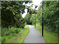
Path beside railway, Feltham
The railway is on the right.
Image: © Robin Webster
Taken: 12 Aug 2017
0.12 miles
3
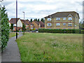
Path towards roundabout on Westmacott Drive, Feltham
Image: © Robin Webster
Taken: 12 Aug 2017
0.15 miles
4
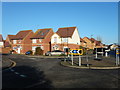
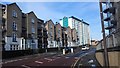
Feltham - Modern Housing Estate
Westmacott Drive roundabout with Jubilee Way and Trevithick Close
Image: © James Emmans
Taken: 2 Jan 2017
0.16 miles
5
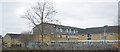
Housing in Highfield Road and Tilley Road
Image: © James Emmans
Taken: 14 Feb 2016
0.18 miles


8
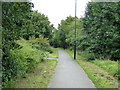
Path beside railway, Feltham
The railway is on the right.
Image: © Robin Webster
Taken: 12 Aug 2017
0.19 miles

10
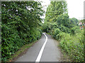
Path from Westmacott Drive to Bedfont Lane
Image: © Robin Webster
Taken: 12 Aug 2017
0.22 miles