IMAGES TAKEN NEAR TO
Queens Keep, Park Road, TWICKENHAM, TW1 2QA
Introduction
This page details the photographs taken nearby to Queens Keep, Park Road, TW1 2QA by members of the Geograph project.
The Geograph project started in 2005 with the aim of publishing, organising and preserving representative images for every square kilometre of Great Britain, Ireland and the Isle of Man.

There are currently over 7.5m images from over14,400 individuals and you can help contribute to the project by visiting https://www.geograph.org.uk
Image Map
Images are licensed for reuse under creativecommons.org/licenses/by-sa/2.0
Notes
- Clicking on the map will re-center to the selected point.
- The higher the marker number, the further away the image location is from the centre of the postcode.
Image Listing (195 Images Found)
Images are licensed for reuse under creativecommons.org/licenses/by-sa/2.0
Image
Details
Distance


3
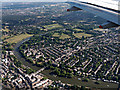
Richmond Bridge from the air
Crossing the Thames between Richmond and St Margarets.
Image: © Thomas Nugent
Taken: 19 Jun 2015
0.11 miles

6

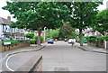
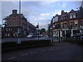
St Margarets Road at the junction of Richmond Road
This is the beginning of the shopping centre in East Twickenham which extends to Richmond Bridge at the other end.
Image: © David Howard
Taken: 9 Sep 2013
0.12 miles

9
St Margarets Road at the junction of Richmond Road
You can see pretty much the whole of the shops here
Image: © David Howard
Taken: 9 Sep 2013
0.12 miles