IMAGES TAKEN NEAR TO
Cambridge Park, TWICKENHAM, TW1 2JH
Introduction
This page details the photographs taken nearby to Cambridge Park, TW1 2JH by members of the Geograph project.
The Geograph project started in 2005 with the aim of publishing, organising and preserving representative images for every square kilometre of Great Britain, Ireland and the Isle of Man.

There are currently over 7.5m images from over14,400 individuals and you can help contribute to the project by visiting https://www.geograph.org.uk
Image Map
Images are licensed for reuse under creativecommons.org/licenses/by-sa/2.0
Notes
- Clicking on the map will re-center to the selected point.
- The higher the marker number, the further away the image location is from the centre of the postcode.
Image Listing (138 Images Found)
Images are licensed for reuse under creativecommons.org/licenses/by-sa/2.0
Image
Details
Distance
1
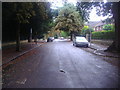
Cambridge Park, East Twickenham
Cambridge Park is more of an estate than an actual road as there are at least four branches to it, a triangle followed by a fork. This is the left point of it.
Image: © David Howard
Taken: 9 Sep 2013
0.07 miles
2

Thames at Richmond from the air, 2001
The Thames sweeps round to Richmond Bridge. On the bend is Glover's Island. Upstream are Ham and Teddington.
Image: © Derek Harper
Taken: 1 Jun 2001
0.10 miles
4
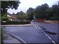
Cambridge Park at the corner of Vivienne Close
Image: © David Howard
Taken: 9 Sep 2013
0.14 miles
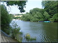
5
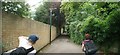
View along the Thames Path towards Richmond
Looking north-northeast.
Image: © Robert Lamb
Taken: 16 Jul 2016
0.14 miles
6
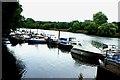
View of boats moored on the Thames at Marble Hill Park
Looking south-southeast.
Image: © Robert Lamb
Taken: 16 Jul 2016
0.15 miles
7
River Thames looking towards Richmond Hill
This was the hottest day of the year with a temperature of 33 degrees and the River Thames was one of the best places to be. This view from the Thames Path near Marble Hill Park looks downriver towards the houses on Richmond Hill. The wooded Glover's Island is on the right, splitting the river into two here.
Image: © Marathon
Taken: 22 Jul 2013
0.15 miles
8
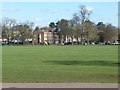
Terraced houses, Beaufort Road
Looking north-east across Marble Hill Park.
Image: © Christine Johnstone
Taken: 4 Mar 2016
0.17 miles
9
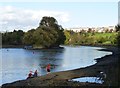
Glover's Island
With canoeists at low tide.
Houses on Richmond Hill in the distance.
Image: © Russel Wills
Taken: 1 Nov 2014
0.17 miles
10
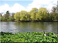
The River Thames near Richmond
Taken from the Thames Path.
Image: © David Purchase
Taken: 26 Apr 2013
0.17 miles