IMAGES TAKEN NEAR TO
Courtlands Avenue, HAMPTON, TW12 3NT
Introduction
This page details the photographs taken nearby to Courtlands Avenue, TW12 3NT by members of the Geograph project.
The Geograph project started in 2005 with the aim of publishing, organising and preserving representative images for every square kilometre of Great Britain, Ireland and the Isle of Man.

There are currently over 7.5m images from over14,400 individuals and you can help contribute to the project by visiting https://www.geograph.org.uk
Image Map
Images are licensed for reuse under creativecommons.org/licenses/by-sa/2.0
Notes
- Clicking on the map will re-center to the selected point.
- The higher the marker number, the further away the image location is from the centre of the postcode.
Image Listing (46 Images Found)
Images are licensed for reuse under creativecommons.org/licenses/by-sa/2.0
Image
Details
Distance
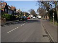
2
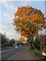
Oak Avenue, Hampton
There are some fine old trees here - oaks which date back to days well before the area was developed as a residential suburb.
Image: © Stefan Czapski
Taken: 1 Dec 2013
0.09 miles
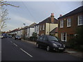
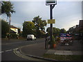
4
Oak Avenue
Oak Avenue passing Courtlands Avenue
Image: © Shaun Ferguson
Taken: 15 Feb 2013
0.10 miles
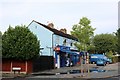
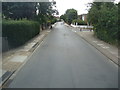
5
Corner of South Road and Oak Avenue, Hampton
The Royal Oak pub is on the right.
Image: © David Howard
Taken: 24 Oct 2011
0.11 miles
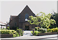
7
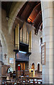
All Saints, The Avenue, Hampton - South aisle
Image: © John Salmon
Taken: 7 May 2013
0.12 miles
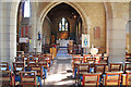
9
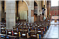
All Saints, The Avenue, Hampton - Interior
Image: © John Salmon
Taken: 7 May 2013
0.12 miles