IMAGES TAKEN NEAR TO
Warwick Close, HAMPTON, TW12 2UA
Introduction
This page details the photographs taken nearby to Warwick Close, TW12 2UA by members of the Geograph project.
The Geograph project started in 2005 with the aim of publishing, organising and preserving representative images for every square kilometre of Great Britain, Ireland and the Isle of Man.

There are currently over 7.5m images from over14,400 individuals and you can help contribute to the project by visiting https://www.geograph.org.uk
Image Map
Images are licensed for reuse under creativecommons.org/licenses/by-sa/2.0
Notes
- Clicking on the map will re-center to the selected point.
- The higher the marker number, the further away the image location is from the centre of the postcode.
Image Listing (81 Images Found)
Images are licensed for reuse under creativecommons.org/licenses/by-sa/2.0
Image
Details
Distance
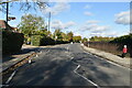
3
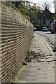
Boundary Wall to Bushy Park
Grade II listed. https://historicengland.org.uk/listing/the-list/list-entry/1358060
Image: © N Chadwick
Taken: 7 Nov 2019
0.04 miles
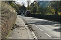
5

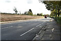
High Street Hampton at the junction of Uxbridge Road
Image: © David Howard
Taken: 29 Jun 2014
0.08 miles
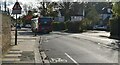
7
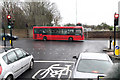
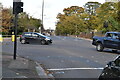
A311, A312 Junction
Seen from the Wingate & Finchley FC team coach on route to Imber Court for the Ryman League Cup Final. This view is looking across the A311 from the A312. Beyond the wall are allotments beside Bushy Park. The street sign in front of the bus indicates High Street Hampton Hill to the left and High Street Hampton to the right.
Image: © Martin Addison
Taken: 30 Mar 2011
0.10 miles