IMAGES TAKEN NEAR TO
Wensleydale Road, HAMPTON, TW12 2LX
Introduction
This page details the photographs taken nearby to Wensleydale Road, TW12 2LX by members of the Geograph project.
The Geograph project started in 2005 with the aim of publishing, organising and preserving representative images for every square kilometre of Great Britain, Ireland and the Isle of Man.

There are currently over 7.5m images from over14,400 individuals and you can help contribute to the project by visiting https://www.geograph.org.uk
Image Map
Images are licensed for reuse under creativecommons.org/licenses/by-sa/2.0
Notes
- Clicking on the map will re-center to the selected point.
- The higher the marker number, the further away the image location is from the centre of the postcode.
Image Listing (18 Images Found)
Images are licensed for reuse under creativecommons.org/licenses/by-sa/2.0
Image
Details
Distance
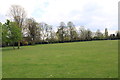
1
Carlie Park Pavilion
Cricket Pavilion and Children's creche
Image: © Peter Dixon
Taken: 24 Apr 2012
0.08 miles
3
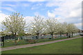
Carlisle Park, Hampton - children's play area fronted by Flowering cherries
Image: © Peter Dixon
Taken: 24 Apr 2012
0.08 miles
4
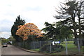
Entrance to Carlisle Park from Carlisle Road
Image: © Peter Dixon
Taken: 24 Apr 2012
0.08 miles
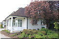
5
Shooting Star Children's Hospice
This is in Hampton
Image: © steve
Taken: 21 Jun 2005
0.12 miles
8
Carlisle Road, Hampton Middx
Standing with back to Carlisle Park and looking down the centre of the road
Image: © Peter Dixon
Taken: 24 Apr 2012
0.17 miles
10
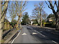
Wensleydale Road
Wensleydale Road junction with Broad Street
Image: © Shaun Ferguson
Taken: 15 Feb 2013
0.17 miles