IMAGES TAKEN NEAR TO
Percy Road, HAMPTON, TW12 2JT
Introduction
This page details the photographs taken nearby to Percy Road, TW12 2JT by members of the Geograph project.
The Geograph project started in 2005 with the aim of publishing, organising and preserving representative images for every square kilometre of Great Britain, Ireland and the Isle of Man.

There are currently over 7.5m images from over14,400 individuals and you can help contribute to the project by visiting https://www.geograph.org.uk
Image Map
Images are licensed for reuse under creativecommons.org/licenses/by-sa/2.0
Notes
- Clicking on the map will re-center to the selected point.
- The higher the marker number, the further away the image location is from the centre of the postcode.
Image Listing (54 Images Found)
Images are licensed for reuse under creativecommons.org/licenses/by-sa/2.0
Image
Details
Distance
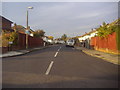
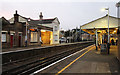
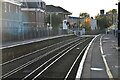
4
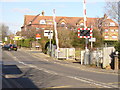
Percy Road, Hampton
The Shepperton branch line crosses Percy Road close to Hampton Junior School.
http://en.wikipedia.org/wiki/Hampton,_London
Image: © Colin Smith
Taken: 25 Feb 2012
0.14 miles
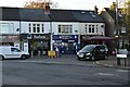
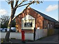
8
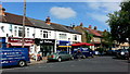
Row of shops, Milton Road, Hampton
A 'villagey' feel to the centre of this outer suburb of the Capital City.
Image: © Jonathan Billinger
Taken: 4 Jul 2015
0.15 miles