IMAGES TAKEN NEAR TO
Priory Road, HAMPTON, TW12 2EY
Introduction
This page details the photographs taken nearby to Priory Road, TW12 2EY by members of the Geograph project.
The Geograph project started in 2005 with the aim of publishing, organising and preserving representative images for every square kilometre of Great Britain, Ireland and the Isle of Man.

There are currently over 7.5m images from over14,400 individuals and you can help contribute to the project by visiting https://www.geograph.org.uk
Image Map
Images are licensed for reuse under creativecommons.org/licenses/by-sa/2.0
Notes
- Clicking on the map will re-center to the selected point.
- The higher the marker number, the further away the image location is from the centre of the postcode.
Image Listing (19 Images Found)
Images are licensed for reuse under creativecommons.org/licenses/by-sa/2.0
Image
Details
Distance
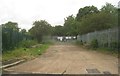
1
Oldfield Road, Hampton
Oldfield Road makes a sharp bend here. Light industry and car repair premises are to the right while on the left, beyond the metal fence, is Hydes Field. Hydes Field, which is now largely scrub, is best seen from the railway between Sunbury and Hampton as it is not properly accessible.
Image: © Marathon
Taken: 26 Mar 2014
0.06 miles
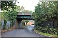
3
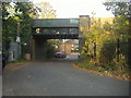
Railway bridge over Oldfield Road, Hampton
Image: © David Howard
Taken: 24 Oct 2011
0.09 miles
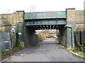
4
Railway bridge on Oldfield Road, Hampton
Image: © David Howard
Taken: 16 Aug 2018
0.10 miles
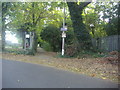
5
Bridge over Oldfield Road
The Thames Valley Railway opened on 1st November 1864 between the Kingston Loop south of Twickenham to Shepperton. Hampton station also opened on 1st November 1864. Within a year the line was taken over by the London & South Western Railway. When it opened the branch was a meandering single line through small communities. It was described as "crossing a flat and somewhat dreary region of Middlesex to terminate in a potato field, as if weary of going further in such country". A double track was provided as far as Fulwell in about 1867, and further doubling reached Sunbury in 1878 following the sale of the Kempton Manor estate for conversion to a racecourse.
There was no really significant residential development along the line before 1914. At Hampton, a large estate called Marling Park to the north of the station was laid out for building in mid-Victorian times but filled only very slowly. The large gaps in the service during the first 40 years cannot have helped - four hours each way in the afternoon between trains.
This bridge is seen from Oldfield Road, with Priory Road on the other side. Hampton is the next station to the right and Kempton Park Racecourse station the next one to the left. Until June 2006 the latter only opened for events at Kempton Park Racecourse, but since then it has had a regular timetable each day.
Image: © Marathon
Taken: 26 Mar 2014
0.10 miles
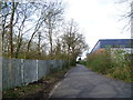
6
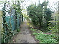
Footpath on Priory Road, Hampton
This runs along the railway line to Kempton Park
Image: © David Howard
Taken: 24 Oct 2011
0.12 miles
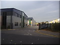
8
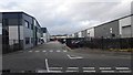
Kempton Gate Business Centre
A Business centre built in 2008 with 17 units.
http://www.kemptongate.co.uk/
Image: © James Emmans
Taken: 21 Feb 2016
0.14 miles
9
Footpath off Oldfield Road, Hampton
Oldfield Road makes a sharp bend here. Leading off it is this footpath which leads to Upper Sunbury Road. Beyond the metal fence on the right is Hydes Field. Hydes Field, which is now largely scrub, is best seen from the railway between Sunbury and Hampton as it is not properly accessible.
Image: © Marathon
Taken: 26 Mar 2014
0.15 miles