IMAGES TAKEN NEAR TO
Holly Road, HAMPTON, TW12 1QH
Introduction
This page details the photographs taken nearby to Holly Road, TW12 1QH by members of the Geograph project.
The Geograph project started in 2005 with the aim of publishing, organising and preserving representative images for every square kilometre of Great Britain, Ireland and the Isle of Man.

There are currently over 7.5m images from over14,400 individuals and you can help contribute to the project by visiting https://www.geograph.org.uk
Image Map
Images are licensed for reuse under creativecommons.org/licenses/by-sa/2.0
Notes
- Clicking on the map will re-center to the selected point.
- The higher the marker number, the further away the image location is from the centre of the postcode.
Image Listing (90 Images Found)
Images are licensed for reuse under creativecommons.org/licenses/by-sa/2.0
Image
Details
Distance

2
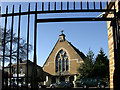
United Reformed Church, Hampton Hill
From the entrance gate to Bushy Park.
The church dates from 1863.
Image: © Des Blenkinsopp
Taken: 8 Feb 2011
0.08 miles
3
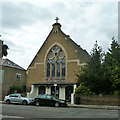
United Reformed Church, Hampton Hill
On High Street.
Image: © Robin Webster
Taken: 16 Sep 2012
0.08 miles
5
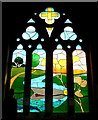
East window, Hampton Hill United Reformed Church
The new stained glass window was unveiled in May 2018.
It was designed by the late father-in-law of the photographer.
See Image
Image: © Jonathan Billinger
Taken: 9 Sep 2018
0.09 miles
6
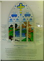
Explanatory notice for the URC window at Hampton Hill
The notice describes the thoughts behind the design of the window by the photographer's late father-in-law.
See Image
Image: © Jonathan Billinger
Taken: 9 Sep 2018
0.09 miles

8
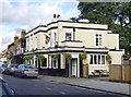
Hampton Hill pubs: (2) 'The Star'
Hampton Hill High Street is well provided with pubs: 'The Rising Sun', 'The Star', and 'The Bloated Mallard' (formerly known as 'The Duke of Clarence'). All three are among the High Street's older buildings. From the style of the building, my guess was that 'The Star' dates from the 1830's (possibly earlier), but a web-search failed to cast much light on its history - there are even suggestions that it was built as late as 1898. To me, that seems unlikely, but old photographs must exist which would help sort the matter out.
Image: © Stefan Czapski
Taken: 26 Sep 2012
0.09 miles
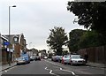
9
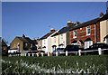
School Road Avenue
Victorian terraced housing typical of this part of Hampton Hill pictured from the corner of the football pitch in the small park opposite.
Image: © Des Blenkinsopp
Taken: 8 Feb 2011
0.10 miles
