IMAGES TAKEN NEAR TO
High Street, HAMPTON, TW12 1NA
Introduction
This page details the photographs taken nearby to High Street, TW12 1NA by members of the Geograph project.
The Geograph project started in 2005 with the aim of publishing, organising and preserving representative images for every square kilometre of Great Britain, Ireland and the Isle of Man.

There are currently over 7.5m images from over14,400 individuals and you can help contribute to the project by visiting https://www.geograph.org.uk
Image Map (Loading...)


Getting Data...Please wait
Leaflet Map data © OpenStreetMap
Images are licensed for reuse under creativecommons.org/licenses/by-sa/2.0
Notes
- Clicking on the map will re-center to the selected point.
- The higher the marker number, the further away the image location is from the centre of the postcode.
Image Listing (82 Images Found)
Images are licensed for reuse under creativecommons.org/licenses/by-sa/2.0
Image
Details
Distance

2
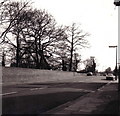
The Pantile Bridge, Hampton Hill
A view of the Pantile Bridge in Hampton Hill taken in glorious black and white in the winter of 1974/75. The bridge takes the A311 over the Longford River where it flows into Bushy Park.
I remember this view very well, as it is where I waited for my No.267 bus to school from 1968 until 1975. (The buses weren't quite as infrequent as this last comment seems to suggest, although sometimes it felt like it!).
If anybody looking at this picture has a copy of "The birth and growth of Hampton Hill" edited by Margery Orton and published in 1965, they might like to compare this with the 1890s picture facing page 54. to the right of the bridge was a 'watersplash', and some of the trees are still recognisable 80 years on.
Image: © Stephen Williams
Taken: Unknown
0.02 miles

4
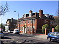
Former Territorial Army building, Hampton Hill.
This was originally a regimental HQ and still bears an inscription above the door. It has since been restored and turned into an office block. It has also been quite sympathetically extended (off picture to the right) with the addition of a new wing which, while modern in style keeps to an appropriate scale and uses similar materials.
Image: © Stephen Williams
Taken: 21 Mar 2007
0.04 miles
5

Longford River from Pantile Bridge
Going through Bushy Park
Image: © David Howard
Taken: 29 Jun 2014
0.04 miles
6
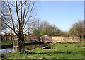
Longford River in Bushy Park
This is the Pantile Bridge as seen from the banks of the Longford River in Bushy Park.
Image: © Stephen Williams
Taken: 21 Mar 2007
0.04 miles
7
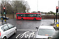
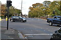
A311, A312 Junction
Seen from the Wingate & Finchley FC team coach on route to Imber Court for the Ryman League Cup Final. This view is looking across the A311 from the A312. Beyond the wall are allotments beside Bushy Park. The street sign in front of the bus indicates High Street Hampton Hill to the left and High Street Hampton to the right.
Image: © Martin Addison
Taken: 30 Mar 2011
0.05 miles
8
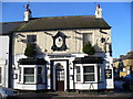
The Rising Sun
Local pub, on Hampton Hill High Street, in Christmas garb.
Image: © Colin Smith
Taken: 10 Dec 2009
0.05 miles
9
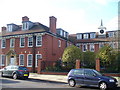
Demobbed Barracks, Hampton Hill
This fine red brick block on Hampton Hill Street carries the Middlesex Regiment crest above its door. It is now occupied by offices.
Image: © Colin Smith
Taken: 10 Dec 2009
0.05 miles