IMAGES TAKEN NEAR TO
Laurel Road, HAMPTON, TW12 1JH
Introduction
This page details the photographs taken nearby to Laurel Road, TW12 1JH by members of the Geograph project.
The Geograph project started in 2005 with the aim of publishing, organising and preserving representative images for every square kilometre of Great Britain, Ireland and the Isle of Man.

There are currently over 7.5m images from over14,400 individuals and you can help contribute to the project by visiting https://www.geograph.org.uk
Image Map
Images are licensed for reuse under creativecommons.org/licenses/by-sa/2.0
Notes
- Clicking on the map will re-center to the selected point.
- The higher the marker number, the further away the image location is from the centre of the postcode.
Image Listing (54 Images Found)
Images are licensed for reuse under creativecommons.org/licenses/by-sa/2.0
Image
Details
Distance

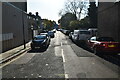
7
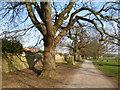
The boundary of Bushy Park
Bushy was one of the three parks enclosed by Cardinal Wolsey in the early 16th century as part of his Hampton Court estate which was built from 1515 and given to Henry VIII along with the palace in 1525. In 1638-9 Charles I had a tributary of the River Colne diverted through Bushy Park to form the Longford River, bringing water right into the grounds of Hampton Court Palace. This provided a water supply for the numerous water features in the parks. Numerous smaller ponds and other water features in Bushy Park have been added at various times since the 16th century.
This is the far north-western edge of the park, between Hampton Hill New Gate and Laurel Road Gate which is just ahead. The impressive wall of the park can be seen on the left.
Image: © Marathon
Taken: 12 Mar 2014
0.07 miles
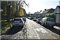
8
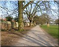
Path along the edge of Bushy Park
Bushy was one of the three parks enclosed by Cardinal Wolsey in the early 16th century as part of his Hampton Court estate which was built from 1515 and given to Henry VIII along with the palace in 1525. In 1638-9 Charles I had a tributary of the River Colne diverted through Bushy Park to form the Longford River, bringing water right into the grounds of Hampton Court Palace. This provided a water supply for the numerous water features in the parks. Numerous smaller ponds and other water features in Bushy Park have been added at various times since the 16th century.
This is the far north-western edge of the park, between Hampton Hill New Gate and Laurel Road Gate which is just ahead. The impressive wall of the park can be seen on the left.
Image: © Marathon
Taken: 12 Mar 2014
0.07 miles
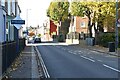
9
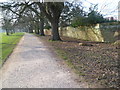
The edge of Bushy Park
Bushy was one of the three parks enclosed by Cardinal Wolsey in the early 16th century as part of his Hampton Court estate which was built from 1515 and given to Henry VIII along with the palace in 1525. In 1638-9 Charles I had a tributary of the River Colne diverted through Bushy Park to form the Longford River, bringing water right into the grounds of Hampton Court Palace. This provided a water supply for the numerous water features in the parks. Numerous smaller ponds and other water features in Bushy Park have been added at various times since the 16th century.
This is the far north-western edge of the park, between Laurel Road Gate and Hampton Hill New Gate. The impressive wall of the park can be seen on the right.
Image: © Marathon
Taken: 12 Mar 2014
0.07 miles
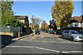
10
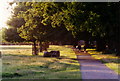
Path in Bushy Park
The perimeter path along the northern side of Bushy Park on a sunny evening in 1996.
Image: © Stephen Williams
Taken: Unknown
0.08 miles