IMAGES TAKEN NEAR TO
Uxbridge Road, HAMPTON, TW12 1BL
Introduction
This page details the photographs taken nearby to Uxbridge Road, TW12 1BL by members of the Geograph project.
The Geograph project started in 2005 with the aim of publishing, organising and preserving representative images for every square kilometre of Great Britain, Ireland and the Isle of Man.

There are currently over 7.5m images from over14,400 individuals and you can help contribute to the project by visiting https://www.geograph.org.uk
Image Map
Images are licensed for reuse under creativecommons.org/licenses/by-sa/2.0
Notes
- Clicking on the map will re-center to the selected point.
- The higher the marker number, the further away the image location is from the centre of the postcode.
Image Listing (70 Images Found)
Images are licensed for reuse under creativecommons.org/licenses/by-sa/2.0
Image
Details
Distance
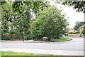
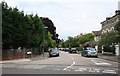
1
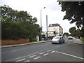
Uxbridge Road at the junction of Windmill Road
Image: © David Howard
Taken: 29 Jun 2014
0.03 miles
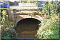
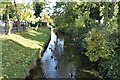
3
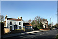
Oxford Cottage, Uxbridge Road
One of the nicest old houses in Hampton Hill.
The Longford river is just beyond, flowing under the road where the brick wall is.
Image: © Des Blenkinsopp
Taken: 8 Feb 2011
0.04 miles
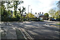
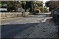
6
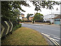
Uxbridge Road at the junction of Windmill Road
Image: © David Howard
Taken: 29 Jun 2014
0.05 miles