IMAGES TAKEN NEAR TO
Cassilis Road, TWICKENHAM, TW1 1RU
Introduction
This page details the photographs taken nearby to Cassilis Road, TW1 1RU by members of the Geograph project.
The Geograph project started in 2005 with the aim of publishing, organising and preserving representative images for every square kilometre of Great Britain, Ireland and the Isle of Man.

There are currently over 7.5m images from over14,400 individuals and you can help contribute to the project by visiting https://www.geograph.org.uk
Image Map
Images are licensed for reuse under creativecommons.org/licenses/by-sa/2.0
Notes
- Clicking on the map will re-center to the selected point.
- The higher the marker number, the further away the image location is from the centre of the postcode.
Image Listing (63 Images Found)
Images are licensed for reuse under creativecommons.org/licenses/by-sa/2.0
Image
Details
Distance
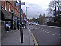
1
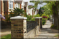
Cassilis Road, St Margarets
Solid Edwardian semi-detached houses on the north-eastern side of Cassilis Road.
Image: © Stephen McKay
Taken: 26 Apr 2017
0.01 miles
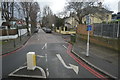
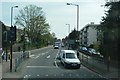
5
Heathcote Rd
This is the view up Heathcote Rd from the junction with Cassilis Rd.
Image: © Nigel Mykura
Taken: 19 Sep 2010
0.08 miles
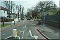
9
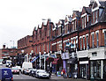
St Margarets Road, St Margarets
The front of St Margarets station can be seen at the end of the parade of shops. Taken from the corner of Westmorland Close.
Image: © David Kemp
Taken: 13 Aug 2008
0.10 miles