IMAGES TAKEN NEAR TO
St. Margarets Road, TWICKENHAM, TW1 1PS
Introduction
This page details the photographs taken nearby to St. Margarets Road, TW1 1PS by members of the Geograph project.
The Geograph project started in 2005 with the aim of publishing, organising and preserving representative images for every square kilometre of Great Britain, Ireland and the Isle of Man.

There are currently over 7.5m images from over14,400 individuals and you can help contribute to the project by visiting https://www.geograph.org.uk
Image Map
Images are licensed for reuse under creativecommons.org/licenses/by-sa/2.0
Notes
- Clicking on the map will re-center to the selected point.
- The higher the marker number, the further away the image location is from the centre of the postcode.
Image Listing (82 Images Found)
Images are licensed for reuse under creativecommons.org/licenses/by-sa/2.0
Image
Details
Distance
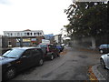
2
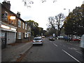
St Margarets Road
Beaver Tool Hire is on the left
Image: © David Howard
Taken: 18 Oct 2014
0.02 miles
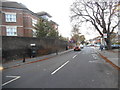
3
St.Margarets Road
Seen from the junction with Railshead Road. The sign on the left welcomes people to Richmond-upon-Thames.
Image: © Martin Addison
Taken: 6 Apr 2012
0.02 miles


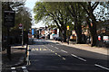
8
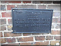
Old sign on the Crane bridge, Richmond Road
There are a number of these in the area, these either side of this bridge, two more in Twickenham and a Surrey council one in Barnes.
Image: © David Howard
Taken: 18 Oct 2014
0.05 miles
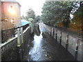
9
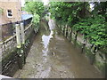
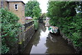
The River Crane
Picture taken from St Margaret's Road.It is only 8.5 miles (13.6 km) long.
Image: © Richard Rogerson
Taken: 12 May 2017
0.06 miles