IMAGES TAKEN NEAR TO
London Road, TWICKENHAM, TW1 1HA
Introduction
This page details the photographs taken nearby to London Road, TW1 1HA by members of the Geograph project.
The Geograph project started in 2005 with the aim of publishing, organising and preserving representative images for every square kilometre of Great Britain, Ireland and the Isle of Man.

There are currently over 7.5m images from over14,400 individuals and you can help contribute to the project by visiting https://www.geograph.org.uk
Image Map
Images are licensed for reuse under creativecommons.org/licenses/by-sa/2.0
Notes
- Clicking on the map will re-center to the selected point.
- The higher the marker number, the further away the image location is from the centre of the postcode.
Image Listing (83 Images Found)
Images are licensed for reuse under creativecommons.org/licenses/by-sa/2.0
Image
Details
Distance
2
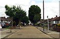
Fulwood Gardens
Nice set of 1930s houses. The church tower at the end of the road is All Hallows church. Until 1939 this was in Leadenhall St in the city, but it was rebuilt in Twickenham after its church was demolished. Designed by Sir Christopher Wren.
Image: © Rob Smith
Taken: 2 Jun 2006
0.13 miles
3
![Twickenham railway station [3]](https://s2.geograph.org.uk/geophotos/07/04/21/7042170_7ee78fd9_120x120.jpg)
Twickenham railway station [3]
A view from the footbridge of the disused lines and platforms.
Twickenham railway station opened in 1848 and was resited some 250 yards east to a new station in 1954. Major redevelopment has taken place in recent years. The station is a stop on the following lines: Waterloo to Reading; Waterloo to Windsor; Hounslow Loop; Kingston Loop:
Image: © Michael Dibb
Taken: 19 Aug 2021
0.15 miles
4
![Twickenham railway station [5]](https://s1.geograph.org.uk/geophotos/07/04/21/7042197_9d5b0d58_120x120.jpg)
Twickenham railway station [5]
Looking along the rails in the direction of Waterloo.
Twickenham railway station opened in 1848 and was resited some 250 yards east to a new station in 1954. Major redevelopment has taken place in recent years. The station is a stop on the following lines: Waterloo to Reading; Waterloo to Windsor; Hounslow Loop; Kingston Loop:
Image: © Michael Dibb
Taken: 19 Aug 2021
0.15 miles
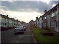
5
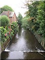
The River Crane (2)
Downstream from the bridge north of Twickenham railway station.
Image: © Mike Quinn
Taken: 31 Jul 2008
0.15 miles
7
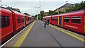
Twickenham station - platforms 4 & 5
The 18.50 Shepperton - London Waterloo service, departing at 19.04, is on the left. On the right, just arrived, is the 19.03 departure to Waterloo (and also from Waterloo), anti-clockwise around the Strawberry Hill loop.
Image: © Peter Whatley
Taken: 27 Jul 2023
0.15 miles
8
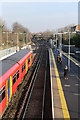
Twickenham Station
Viewed from the footbridge on the path between Beauchamp Road and Cole Park Road and looking along the up (Waterloo bound) lines. The train standing in platform 3 is a Waterloo bound all stations service formed of two class 455 electric units (the leading unit is 5734). The passengers on platform 2 are awaiting a semi-fast Waterloo service.
Image: © Martin Addison
Taken: 23 Jan 2015
0.15 miles
9
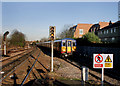
Train at Twickenham
Bright evening sunlight at the end of the platform.
Image: © Des Blenkinsopp
Taken: 8 Feb 2011
0.16 miles
10
![Twickenham railway station [1]](https://s3.geograph.org.uk/geophotos/07/04/21/7042167_3b43b6f1_120x120.jpg)
Twickenham railway station [1]
Looking along the rails towards Waterloo.
Twickenham railway station opened in 1848 and was resited some 250 yards east to a new station in 1954. Major redevelopment has taken place in recent years. The station is a stop on the following lines: Waterloo to Reading; Waterloo to Windsor; Hounslow Loop; Kingston Loop:
Image: © Michael Dibb
Taken: 19 Aug 2021
0.16 miles