IMAGES TAKEN NEAR TO
Marlow Crescent, TWICKENHAM, TW1 1DD
Introduction
This page details the photographs taken nearby to Marlow Crescent, TW1 1DD by members of the Geograph project.
The Geograph project started in 2005 with the aim of publishing, organising and preserving representative images for every square kilometre of Great Britain, Ireland and the Isle of Man.

There are currently over 7.5m images from over14,400 individuals and you can help contribute to the project by visiting https://www.geograph.org.uk
Image Map
Images are licensed for reuse under creativecommons.org/licenses/by-sa/2.0
Notes
- Clicking on the map will re-center to the selected point.
- The higher the marker number, the further away the image location is from the centre of the postcode.
Image Listing (56 Images Found)
Images are licensed for reuse under creativecommons.org/licenses/by-sa/2.0
Image
Details
Distance
5
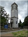
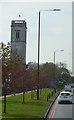
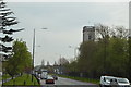
All Hallows, Twickenham
The tower once stood at Lombard St, City of London (All Hallows church) and was removed in or around 1938 and resited at Twickenham.
Image: © Dave Kelly
Taken: 11 Aug 2013
0.10 miles