IMAGES TAKEN NEAR TO
King Edwards Grove, TEDDINGTON, TW11 9LX
Introduction
This page details the photographs taken nearby to King Edwards Grove, TW11 9LX by members of the Geograph project.
The Geograph project started in 2005 with the aim of publishing, organising and preserving representative images for every square kilometre of Great Britain, Ireland and the Isle of Man.

There are currently over 7.5m images from over14,400 individuals and you can help contribute to the project by visiting https://www.geograph.org.uk
Image Map
Images are licensed for reuse under creativecommons.org/licenses/by-sa/2.0
Notes
- Clicking on the map will re-center to the selected point.
- The higher the marker number, the further away the image location is from the centre of the postcode.
Image Listing (14 Images Found)
Images are licensed for reuse under creativecommons.org/licenses/by-sa/2.0
Image
Details
Distance
2
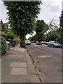
Holmesdale Road
View WSW along Holmesdale Road in Teddington
Image: © Matt Ballantine
Taken: 7 Jun 2017
0.17 miles
3
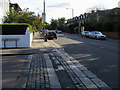
St Winifreds Road
Kingston Road passing St Winifreds Road
Image: © Shaun Ferguson
Taken: 8 Oct 2008
0.20 miles
4
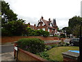
Riverbank house, Teddington
39 Broomwater.
Image: © Robin Webster
Taken: 9 Sep 2012
0.24 miles
5
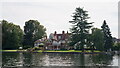
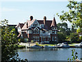
Teddington
Riverside properties, overlooking the River Thames.
Image: © Peter Trimming
Taken: 3 Sep 2023
0.24 miles
6
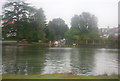
Small channel off the River Thames, Teddington
Image: © N Chadwick
Taken: 25 Aug 2010
0.24 miles
7
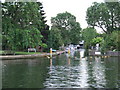
Inlet at Teddington
A short, narrow inlet leading off the River Thames at Teddington.
Image: © Malc McDonald
Taken: 2 Jul 2011
0.24 miles

9
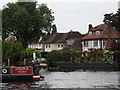
Felix G
Narrowboat passing Broom Water on the River Thames above Teddington.
http://www.riverthames.co.uk/
Image: © Colin Smith
Taken: 31 May 2012
0.24 miles
10
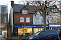
Moore's Cycles on Kingston Road, Hampton Wick
Image: © David Howard
Taken: 20 Nov 2018
0.24 miles