IMAGES TAKEN NEAR TO
Bushy Park Road, TEDDINGTON, TW11 9DG
Introduction
This page details the photographs taken nearby to Bushy Park Road, TW11 9DG by members of the Geograph project.
The Geograph project started in 2005 with the aim of publishing, organising and preserving representative images for every square kilometre of Great Britain, Ireland and the Isle of Man.

There are currently over 7.5m images from over14,400 individuals and you can help contribute to the project by visiting https://www.geograph.org.uk
Image Map
Images are licensed for reuse under creativecommons.org/licenses/by-sa/2.0
Notes
- Clicking on the map will re-center to the selected point.
- The higher the marker number, the further away the image location is from the centre of the postcode.
Image Listing (25 Images Found)
Images are licensed for reuse under creativecommons.org/licenses/by-sa/2.0
Image
Details
Distance
1
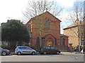
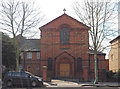
St Mark's Church, Teddington
Church of England parish church, serving South Teddington. See also Image
Image: © Christian K
Taken: Unknown
0.06 miles
3
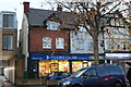
Moore's Cycles on Kingston Road, Hampton Wick
Image: © David Howard
Taken: 20 Nov 2018
0.07 miles
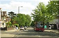
7
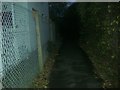
Path along the railway, Teddington
From Bushy Park Road
Image: © David Howard
Taken: 4 Nov 2013
0.16 miles
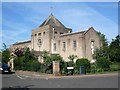
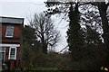
8
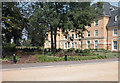
Normansfield Park
Modern apartments on the former Normansfield Hospital site.
Image: © Dennis Turner
Taken: 3 Sep 2005
0.16 miles