IMAGES TAKEN NEAR TO
Cedar Road, TEDDINGTON, TW11 9AL
Introduction
This page details the photographs taken nearby to Cedar Road, TW11 9AL by members of the Geograph project.
The Geograph project started in 2005 with the aim of publishing, organising and preserving representative images for every square kilometre of Great Britain, Ireland and the Isle of Man.

There are currently over 7.5m images from over14,400 individuals and you can help contribute to the project by visiting https://www.geograph.org.uk
Image Map
Images are licensed for reuse under creativecommons.org/licenses/by-sa/2.0
Notes
- Clicking on the map will re-center to the selected point.
- The higher the marker number, the further away the image location is from the centre of the postcode.
Image Listing (119 Images Found)
Images are licensed for reuse under creativecommons.org/licenses/by-sa/2.0
Image
Details
Distance
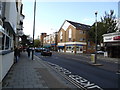
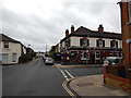
1
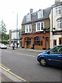
Teddington Arms, 38-40 High Street, Teddington, London
Image: © Oast House Archive
Taken: 11 May 2005
0.02 miles
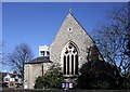

7
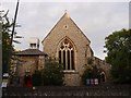
Christ Church
Christ Church, Teddington
Image: © Graeme Smith
Taken: 2 Jul 2011
0.05 miles
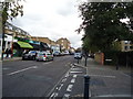
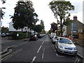
10
The Builders Arms Pub on Field Lane Junction with Bridgeman Road
Image: © James Emmans
Taken: 28 Aug 2016
0.06 miles