IMAGES TAKEN NEAR TO
High Street, TEDDINGTON, TW11 8HD
Introduction
This page details the photographs taken nearby to High Street, TW11 8HD by members of the Geograph project.
The Geograph project started in 2005 with the aim of publishing, organising and preserving representative images for every square kilometre of Great Britain, Ireland and the Isle of Man.

There are currently over 7.5m images from over14,400 individuals and you can help contribute to the project by visiting https://www.geograph.org.uk
Image Map (Loading...)


Getting Data...Please wait
Leaflet Map data © OpenStreetMap
Images are licensed for reuse under creativecommons.org/licenses/by-sa/2.0
Notes
- Clicking on the map will re-center to the selected point.
- The higher the marker number, the further away the image location is from the centre of the postcode.
Image Listing (97 Images Found)
Images are licensed for reuse under creativecommons.org/licenses/by-sa/2.0
Image
Details
Distance

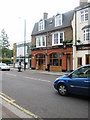
5
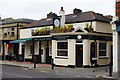
The Clock House, Teddington, Surrey
Public house on the High Street, at the junction with Wades Lane.
Image: © Peter Trimming
Taken: 21 Aug 2010
0.04 miles
6
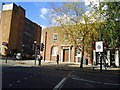
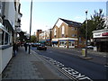
Royal Mail Delivery Office, Teddington
Image: © Stacey Harris
Taken: 16 Oct 2010
0.05 miles
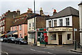
7
Teddington Arms, 38-40 High Street, Teddington, London
Image: © Oast House Archive
Taken: 11 May 2005
0.05 miles
9
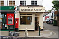
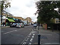
Jeanies Barber Shop
Located on High Street, Teddington. Spot the photographer!
Image: © Peter Trimming
Taken: 21 Aug 2010
0.07 miles
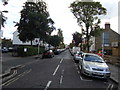
10
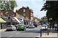
High Street, Teddington
A variety of buildings, near the junction with Watt's Lane.
Image: © Peter Trimming
Taken: 21 Aug 2010
0.07 miles