IMAGES TAKEN NEAR TO
Teddington Park, TEDDINGTON, TW11 8DE
Introduction
This page details the photographs taken nearby to Teddington Park, TW11 8DE by members of the Geograph project.
The Geograph project started in 2005 with the aim of publishing, organising and preserving representative images for every square kilometre of Great Britain, Ireland and the Isle of Man.

There are currently over 7.5m images from over14,400 individuals and you can help contribute to the project by visiting https://www.geograph.org.uk
Image Map
Images are licensed for reuse under creativecommons.org/licenses/by-sa/2.0
Notes
- Clicking on the map will re-center to the selected point.
- The higher the marker number, the further away the image location is from the centre of the postcode.
Image Listing (18 Images Found)
Images are licensed for reuse under creativecommons.org/licenses/by-sa/2.0
Image
Details
Distance
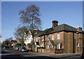
2
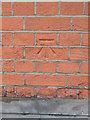
Benchmark on #72 Waldegrave Road, Teddington
This benchmark is on the side wall of #72 Waldegrave Road, which is actually Teddington Park. Some re-pointing has infilled part of the cut mark. Ordnance Survey cut mark benchmark levelled at 9.330m above Newlyn Datum verified 1957.
For a wider view see Image
Image: © John S Turner
Taken: 9 May 2012
0.13 miles
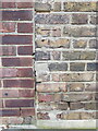
3
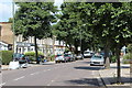
Teddington Park junction with Waldegrave Road, Teddington
There is an Ordnance Survey benchmark on the corner of the house, adjacent to the garden wall Image
Image: © John S Turner
Taken: 9 May 2012
0.13 miles
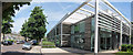
4
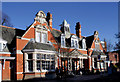
Carnegie Library, Teddington
In the Edwardian Baroque style, this library dates from 1906.
Image: © Des Blenkinsopp
Taken: 8 Feb 2011
0.17 miles
6
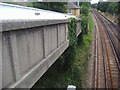
Railway line by Linden Road, Teddington
From the footbridge
Image: © David Howard
Taken: 2 Aug 2009
0.20 miles
8
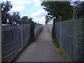
Footbridge over the railway
Between Linden Grove and Somerset Road
Image: © David Howard
Taken: 2 Aug 2009
0.21 miles
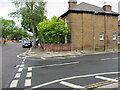
9
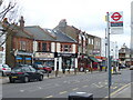
Waldegrave Road
Local shops for local people a little way north of Teddington High Street. The old post office here is now a trendy bistro.
Image: © Colin Smith
Taken: 22 Feb 2009
0.22 miles
10
Bench mark on Carnegie Library, Teddington
This Ordnance Survey bench mark is on the face of the Carnegie Library, Waldegrave Road, Teddington. See also Image
Image: © John S Turner
Taken: 11 Dec 2019
0.22 miles