IMAGES TAKEN NEAR TO
Princes Close, TEDDINGTON, TW11 0RX
Introduction
This page details the photographs taken nearby to Princes Close, TW11 0RX by members of the Geograph project.
The Geograph project started in 2005 with the aim of publishing, organising and preserving representative images for every square kilometre of Great Britain, Ireland and the Isle of Man.

There are currently over 7.5m images from over14,400 individuals and you can help contribute to the project by visiting https://www.geograph.org.uk
Image Map
Images are licensed for reuse under creativecommons.org/licenses/by-sa/2.0
Notes
- Clicking on the map will re-center to the selected point.
- The higher the marker number, the further away the image location is from the centre of the postcode.
Image Listing (68 Images Found)
Images are licensed for reuse under creativecommons.org/licenses/by-sa/2.0
Image
Details
Distance
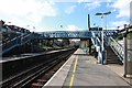
1
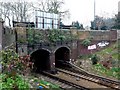
Railway Tunnel Fulwell
This tunnel is where the Shepperton Branch line passes under the A311 road just west of Fulwell station near Richmond.
Image: © Nigel Mykura
Taken: 26 Mar 2011
0.09 miles
6
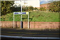
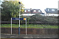
Fulwell railway station, Greater London
Opened in 1864 as Fulwell & Hampton Hill by the London & South Western Railway on the line from Teddington to Shepperton.
View south west towards Hampton and Shepperton.
Image: © Nigel Thompson
Taken: 31 Jan 2015
0.13 miles
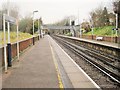
7
Fulwell station, entrance off Clonmel Road
View NNW, Shepperton left, right to London Waterloo via Twickenham or Kingston: ex-LSWR Shepperton branch. (Cf. Image]).
Image: © Ben Brooksbank
Taken: 17 Oct 1993
0.13 miles
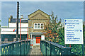
10
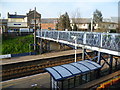
Fulwell station
The Thames Valley Railway opened on 1st November 1864 between the Kingston Loop south of Twickenham to Shepperton. Within a year it was taken over by the London & South Western Railway. When it opened the branch was a meandering single line through small communities. It was described as "crossing a flat and somewhat dreary region of Middlesex to terminate in a potato field, as if weary of going further in such country".
Fulwell (for Hampton Hill) was the first intermediate station and stood in open country. It took its name from the Fulwell Park seat of the Deputy Chairman of the Thames Valley Railway Company, which was half a mile to the north-west. A double track was provided as far as Fulwell in about 1867, and further doubling reached Sunbury in 1878 following the sale of the Kempton Manor estate for conversion to a racecourse.
There was no really significant residential development along the line before 1914, although Teddington crept westwards towards Fulwell station, mostly in the form of low-cost housing. At Fulwell in the late 1920s and early 1930s large housing estates were built north-west, south and south-west of the station.
This is the view of the station looking from the footpath entrance from Clonmel Road on the south side, across the footbridge to the up platform on the other side.
Image: © Marathon
Taken: 12 Mar 2014
0.14 miles