IMAGES TAKEN NEAR TO
Park Street, TEDDINGTON, TW11 0LT
Introduction
This page details the photographs taken nearby to Park Street, TW11 0LT by members of the Geograph project.
The Geograph project started in 2005 with the aim of publishing, organising and preserving representative images for every square kilometre of Great Britain, Ireland and the Isle of Man.

There are currently over 7.5m images from over14,400 individuals and you can help contribute to the project by visiting https://www.geograph.org.uk
Image Map
Images are licensed for reuse under creativecommons.org/licenses/by-sa/2.0
Notes
- Clicking on the map will re-center to the selected point.
- The higher the marker number, the further away the image location is from the centre of the postcode.
Image Listing (57 Images Found)
Images are licensed for reuse under creativecommons.org/licenses/by-sa/2.0
Image
Details
Distance
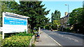
3

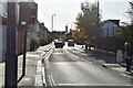
Teddington Memorial Hospital
Main entrance viewed from across the north gridline on Hampton Road.
Image: © Jonathan Billinger
Taken: 4 Jul 2015
0.10 miles

5
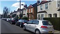
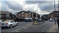
Hampton Road at the junction of Stanley Road
Image: © David Howard
Taken: 29 Jun 2014
0.11 miles
6
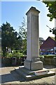
Teddington War Memorial
Grade II listed. https://historicengland.org.uk/listing/the-list/list-entry/1444660
Image: © N Chadwick
Taken: 7 Nov 2019
0.12 miles
7

Teddington War Memorial
Grade II listed. https://historicengland.org.uk/listing/the-list/list-entry/1444660
Image: © N Chadwick
Taken: 7 Nov 2019
0.12 miles
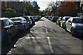
10
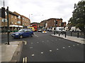
A313 Hampton Road, Teddington
Looking west towards Hampton by the entrance to the Memorial Hospital.
Image: © Jonathan Billinger
Taken: 4 Jul 2015
0.12 miles