IMAGES TAKEN NEAR TO
The Causeway, TEDDINGTON, TW11 0HE
Introduction
This page details the photographs taken nearby to The Causeway, TW11 0HE by members of the Geograph project.
The Geograph project started in 2005 with the aim of publishing, organising and preserving representative images for every square kilometre of Great Britain, Ireland and the Isle of Man.

There are currently over 7.5m images from over14,400 individuals and you can help contribute to the project by visiting https://www.geograph.org.uk
Image Map (Loading...)


Getting Data...Please wait
Leaflet Map data © OpenStreetMap
Images are licensed for reuse under creativecommons.org/licenses/by-sa/2.0
Notes
- Clicking on the map will re-center to the selected point.
- The higher the marker number, the further away the image location is from the centre of the postcode.
Image Listing (139 Images Found)
Images are licensed for reuse under creativecommons.org/licenses/by-sa/2.0
Image
Details
Distance
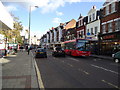
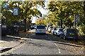
1
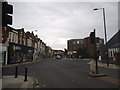
Broad Street at the junction of Queen's Road, Teddington
Image: © David Howard
Taken: 29 Jun 2014
0.02 miles
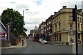
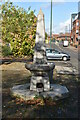
8
Bychurch End
From Church Road looking to Bychurch End by the cross of St Peter and St Paul Church
Image: © Shaun Ferguson
Taken: 8 Oct 2008
0.04 miles
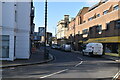
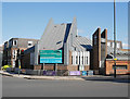
10
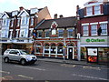
The Hogarth public house, Teddington
Image: © Stacey Harris
Taken: 16 Oct 2010
0.05 miles