IMAGES TAKEN NEAR TO
Widewing Close, TEDDINGTON, TW11 0DY
Introduction
This page details the photographs taken nearby to Widewing Close, TW11 0DY by members of the Geograph project.
The Geograph project started in 2005 with the aim of publishing, organising and preserving representative images for every square kilometre of Great Britain, Ireland and the Isle of Man.

There are currently over 7.5m images from over14,400 individuals and you can help contribute to the project by visiting https://www.geograph.org.uk
Image Map
Images are licensed for reuse under creativecommons.org/licenses/by-sa/2.0
Notes
- Clicking on the map will re-center to the selected point.
- The higher the marker number, the further away the image location is from the centre of the postcode.
Image Listing (30 Images Found)
Images are licensed for reuse under creativecommons.org/licenses/by-sa/2.0
Image
Details
Distance
1
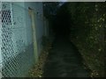
Path along the railway, Teddington
From Bushy Park Road
Image: © David Howard
Taken: 4 Nov 2013
0.05 miles
2
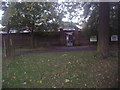
Shaef Gate, Bushy Park
I expect most people coming here think Shaef is someone's name, but once I was told otherwise I found it meant Supreme Headquarters Allied Expeditionary Force, which the road opposite and gate are named after, including a plaque in memory of the troops who fought on the beaches in Normandy.
Image: © David Howard
Taken: 4 Nov 2013
0.06 miles
4
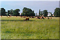
Deer in Bushy Park, 1987
The houses behind the animals lie in Sandy Lane, between Harrowdene Gardens and Bushy Park Road.
Image: © John Baker
Taken: 21 Jun 1987
0.11 miles
5
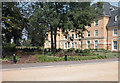
Normansfield Park
Modern apartments on the former Normansfield Hospital site.
Image: © Dennis Turner
Taken: 3 Sep 2005
0.16 miles
6
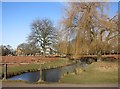
Waterway in Bushy Park
Bushy Park has quite a network of ornamental ponds and streams, based on water from the Longford River, itself a man made canal built to supply Hampton Court Palace.
The path here is Cobblers Walk, a cycleway providing an alternative route through the park if you fancy a change from the London Loop.
Image: © Des Blenkinsopp
Taken: 18 Feb 2015
0.16 miles
9
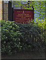
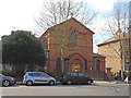
Sacred Heart, Kingston Road - Notice board
Image: © John Salmon
Taken: 28 Mar 2017
0.18 miles
10
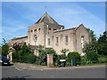
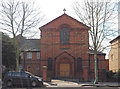
St Mark's Church, Teddington
Church of England parish church, serving South Teddington. See also Image
Image: © Christian K
Taken: Unknown
0.20 miles