IMAGES TAKEN NEAR TO
Sandy Lane, TEDDINGTON, TW11 0DF
Introduction
This page details the photographs taken nearby to Sandy Lane, TW11 0DF by members of the Geograph project.
The Geograph project started in 2005 with the aim of publishing, organising and preserving representative images for every square kilometre of Great Britain, Ireland and the Isle of Man.

There are currently over 7.5m images from over14,400 individuals and you can help contribute to the project by visiting https://www.geograph.org.uk
Image Map
Images are licensed for reuse under creativecommons.org/licenses/by-sa/2.0
Notes
- Clicking on the map will re-center to the selected point.
- The higher the marker number, the further away the image location is from the centre of the postcode.
Image Listing (38 Images Found)
Images are licensed for reuse under creativecommons.org/licenses/by-sa/2.0
Image
Details
Distance
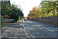
1
The edge of Bushy Park
The wall surrounding Bushy Park can be seen in this photograph as the tints of autumn start to show through.
Image: © Marathon
Taken: 27 Oct 2010
0.04 miles
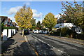
2
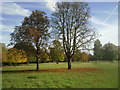
Bushy Park in early autumn
Photographed close to the Teddington entrance to the park, the tints of autumn are starting to show.
Image: © Marathon
Taken: 27 Oct 2010
0.06 miles
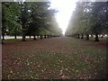
4
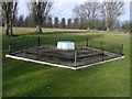
US Army Air-forces Memorial Bushy Park
This monument in Bushy Park remembers Camp Griffiss. It states "This tablet marks the site of the European Headquarters of the United States Army Air Forces July 1942 – December 1944 and is dedicated by the Royal Air Force to their comrades-in-arms.
It is through fraternity that liberty is saved - Victor Hugo."
If you look carefully, you can see cars on Chestnut Avenue in the background.
Image: © Sean Davis
Taken: 29 Mar 2008
0.10 miles
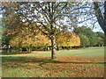
5

Bushy Park wall, Sandy Lane, Teddington
There is an Ordnance Survey benchmark on the white stone set into Bushy Park wall, Sandy Lane: Image
Image: © John S Turner
Taken: 12 May 2012
0.10 miles
6

Benchmark by Sandy Lane, Teddington
Ordnance Survey benchmark set in Bushy Park wall by Sandy Lane, Teddington. For a wider view see: Image
Benchmark Database: https://www.bench-marks.org.uk/bm223863
Image: © John S Turner
Taken: 12 May 2012
0.11 miles