IMAGES TAKEN NEAR TO
Ferrymoor, RICHMOND, TW10 7SD
Introduction
This page details the photographs taken nearby to Ferrymoor, TW10 7SD by members of the Geograph project.
The Geograph project started in 2005 with the aim of publishing, organising and preserving representative images for every square kilometre of Great Britain, Ireland and the Isle of Man.

There are currently over 7.5m images from over14,400 individuals and you can help contribute to the project by visiting https://www.geograph.org.uk
Image Map
Images are licensed for reuse under creativecommons.org/licenses/by-sa/2.0
Notes
- Clicking on the map will re-center to the selected point.
- The higher the marker number, the further away the image location is from the centre of the postcode.
Image Listing (78 Images Found)
Images are licensed for reuse under creativecommons.org/licenses/by-sa/2.0
Image
Details
Distance
1
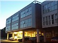
New flats on Croft Way, Ham
These replaced a garage a number of years ago
Image: © David Howard
Taken: 14 Aug 2018
0.04 miles
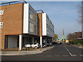
3

Croft Way, Ham
Croft Way in Ham, near Richmond in south west London.
Image: © Malc McDonald
Taken: 9 Jul 2016
0.06 miles
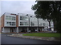
4
Croftway
A short road on the Ashburnham estate in Ham. At the eastern end is the estate church Image; to the left, housing typical of this 1960s estate.
Image: © Stephen Craven
Taken: 14 Mar 2012
0.06 miles
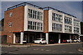
5
Flats on Croft Way, Ham
These flats were built on the site of a garage about five years ago and the commercial space on the ground floor is still unoccupied since they arrived. There were for sale boards up till about a week ago and clearly trying something new after such a long period of failure. There is no idea either what the function of the units would be, or the facing behind the security boards which went up as soon as they were finished.
Image: © David Howard
Taken: 9 Sep 2013
0.06 miles
7

Ham Lands Nature Reserve
Path towards Riverside Drive.
Image: © James Emmans
Taken: 31 Aug 2016
0.06 miles
8
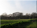
Ham Lands nature reserve
The housing estate at Ham built in the 1960s stopped a couple of hundred metres short of the river, leaving a margin of common land, which is now categorised as a nature reserve, hopefully thereby avoiding future building along the river front.
Image: © Stephen Craven
Taken: 14 Mar 2012
0.07 miles

10

Saint Richard's Church
Saint Richard's Church is an Anglican church on Ashburnham Road, Ham, in the London Borough of Richmond upon Thames.
The church was built as part of a substantial housing development, on land given by the construction company Wates. The foundation stone was laid, on 19 September 1964, by Norman Wates.
Image: © Peter Trimming
Taken: 3 Sep 2023
0.07 miles