IMAGES TAKEN NEAR TO
Link Way, RICHMOND, TW10 7QT
Introduction
This page details the photographs taken nearby to Link Way, TW10 7QT by members of the Geograph project.
The Geograph project started in 2005 with the aim of publishing, organising and preserving representative images for every square kilometre of Great Britain, Ireland and the Isle of Man.

There are currently over 7.5m images from over14,400 individuals and you can help contribute to the project by visiting https://www.geograph.org.uk
Image Map
Images are licensed for reuse under creativecommons.org/licenses/by-sa/2.0
Notes
- Clicking on the map will re-center to the selected point.
- The higher the marker number, the further away the image location is from the centre of the postcode.
Image Listing (56 Images Found)
Images are licensed for reuse under creativecommons.org/licenses/by-sa/2.0
Image
Details
Distance
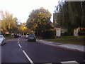
2

Mini-roundabout in Ham, near Richmond
A mini-roundabout at the junction of Riverside Drive and Ashburnham Road, in Ham.
Image: © Malc McDonald
Taken: 9 Jul 2016
0.11 miles
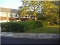
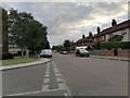
3

Broughton Avenue at the junction of Ashburnham Road
Image: © David Howard
Taken: 16 Jul 2020
0.17 miles
6
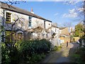
Wiggins and Pointers Cottages, off Wiggins Lane, Ham
Sited along a little alleyway - an arrangement that early photographs show was quite common until Victorian times.
Image: © Stefan Czapski
Taken: 16 Feb 2014
0.19 miles