IMAGES TAKEN NEAR TO
Cave Road, RICHMOND, TW10 7BH
Introduction
This page details the photographs taken nearby to Cave Road, TW10 7BH by members of the Geograph project.
The Geograph project started in 2005 with the aim of publishing, organising and preserving representative images for every square kilometre of Great Britain, Ireland and the Isle of Man.

There are currently over 7.5m images from over14,400 individuals and you can help contribute to the project by visiting https://www.geograph.org.uk
Image Map
Images are licensed for reuse under creativecommons.org/licenses/by-sa/2.0
Notes
- Clicking on the map will re-center to the selected point.
- The higher the marker number, the further away the image location is from the centre of the postcode.
Image Listing (192 Images Found)
Images are licensed for reuse under creativecommons.org/licenses/by-sa/2.0
Image
Details
Distance

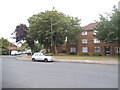
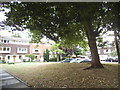
2
Hardwicke Road, Ham
Hardwicke Road in Ham, in south west London.
Image: © Malc McDonald
Taken: 9 Jul 2016
0.04 miles
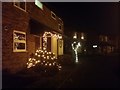
3
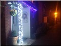
It's Christmas!
Lights on Locksmeade Road, Ham
Image: © David Howard
Taken: 11 Dec 2018
0.04 miles
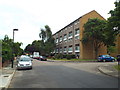
5
Kingfisher Drive at the junction of Hardwicke Road
Image: © David Howard
Taken: 27 Jul 2014
0.05 miles
6

Path from Dukes Avenue to Teddington
This is the only access across the river Thames between Richmond and Kingston but only for pedestrians and cyclists.
Image: © David Howard
Taken: 12 Aug 2013
0.06 miles
7
Christmas lights on Thamesgate Close, Ham
Image: © David Howard
Taken: 11 Dec 2018
0.06 miles
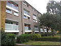
8
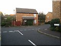
Tideway Close at the junction of Locksmeade Road
Image: © David Howard
Taken: 27 Sep 2018
0.06 miles