IMAGES TAKEN NEAR TO
Hazel Lane, RICHMOND, TW10 7AP
Introduction
This page details the photographs taken nearby to Hazel Lane, TW10 7AP by members of the Geograph project.
The Geograph project started in 2005 with the aim of publishing, organising and preserving representative images for every square kilometre of Great Britain, Ireland and the Isle of Man.

There are currently over 7.5m images from over14,400 individuals and you can help contribute to the project by visiting https://www.geograph.org.uk
Image Map
Images are licensed for reuse under creativecommons.org/licenses/by-sa/2.0
Notes
- Clicking on the map will re-center to the selected point.
- The higher the marker number, the further away the image location is from the centre of the postcode.
Image Listing (39 Images Found)
Images are licensed for reuse under creativecommons.org/licenses/by-sa/2.0
Image
Details
Distance
1
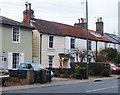
Weather-boarded cottage in Petersham Road
Nineteenth-century photographs show that many buildings in the area around Richmond were once weatherboarded. This little cottage is one of very few which remain in anything like their original state. The cottages to the right are built on a very similar scale, so perhaps the whole of this little terrace was once weather-boarded.
Weather-boarding is said to have flourished from 1784, when the British government imposed a tax on bricks (eventually abolished in 1850).
A collection of early photographs is held in Richmond Borough's Local Studies Collection, at the Old Town Hall, Whittaker Avenue, Richmond. Some images are available on-line:
www.richmond.gov.uk/.../local.../local_studies.../about_local_studies.htm
Image: © Stefan Czapski
Taken: 1 Jan 2011
0.05 miles
2
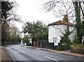
Petersham Road, with weather-boarded cottage
Looking south along Petersham Road. Early photographs show that many buildings in the Richmond area were once weather-boarded - even in Richmond town centre. The building seen here is partly weather-boarded - part (not visible from this angle) is hung with shingles. Weather-boarding became widespread during a period when a tax was levied on bricks (from 1784 to 1850).
For another example nearby, see: Image
Image: © Stefan Czapski
Taken: 1 Jan 2011
0.06 miles
3
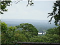
View of the inky landscape from Richmond Park
Looking west from near Pembroke Lodge. The landscape is like ink against the cloudy, hazy sky!
Image: © Robert Lamb
Taken: 1 Jul 2012
0.08 miles
4
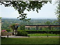
View of the inky landscape from Richmond Park #2
Looking west from near Pembroke Lodge.
Image: © Robert Lamb
Taken: 1 Jul 2012
0.09 miles
5
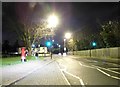
Petersham Road at the junction of Sandy Lane, Ham
Image: © David Howard
Taken: 23 Dec 2014
0.12 miles
6
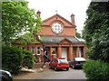
Sudbrook Nursery School, Petersham
The school, which teaches nursery aged children according to the Steiner method, occupies the former village hall in the grounds of All Saints church Image There is Biblical text over the door and a similar ecclesiastical architectural style.
Image: © Stephen Craven
Taken: 9 May 2008
0.13 miles
7
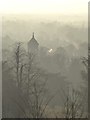
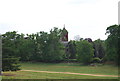
The tower of All Saints' Church, Petersham, seen from King Henry's Mound
Image: © Stefan Czapski
Taken: 13 Feb 2017
0.14 miles

9
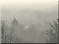
View in mist of All Saints' Church, Petersham - seen from King Henry's Mound
Image: © Stefan Czapski
Taken: 13 Feb 2017
0.14 miles
10
Church of All Saints, Petersham
Grade II listed. http://www.britishlistedbuildings.co.uk/en-205248-church-of-all-saints-richmond
Image: © N Chadwick
Taken: 7 May 2011
0.14 miles