IMAGES TAKEN NEAR TO
Petersham Road, RICHMOND, TW10 7AB
Introduction
This page details the photographs taken nearby to Petersham Road, TW10 7AB by members of the Geograph project.
The Geograph project started in 2005 with the aim of publishing, organising and preserving representative images for every square kilometre of Great Britain, Ireland and the Isle of Man.

There are currently over 7.5m images from over14,400 individuals and you can help contribute to the project by visiting https://www.geograph.org.uk
Image Map
Images are licensed for reuse under creativecommons.org/licenses/by-sa/2.0
Notes
- Clicking on the map will re-center to the selected point.
- The higher the marker number, the further away the image location is from the centre of the postcode.
Image Listing (147 Images Found)
Images are licensed for reuse under creativecommons.org/licenses/by-sa/2.0
Image
Details
Distance
1
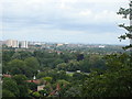
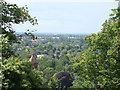
View of the west from Richmond Park #9
Looking west.
Image: © Robert Lamb
Taken: 1 Jul 2012
0.03 miles
2
View of the west from Richmond Park #2
Looking west.
Image: © Robert Lamb
Taken: 1 Jul 2012
0.04 miles
3
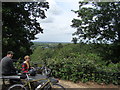
View of the west from Richmond Park #4
Looking west.
Image: © Robert Lamb
Taken: 1 Jul 2012
0.04 miles
4
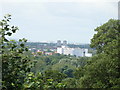
View of a mosque and gasometer from Richmond Park
Looking west.
Image: © Robert Lamb
Taken: 1 Jul 2012
0.04 miles
5
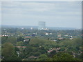
View of the west from Richmond Park #3
Looking west. Dominating this scene is the church on Bute Avenue, which I can't identify as Google Streetview doesn't touch that road (see https://www.google.co.uk/maps?q=richmond&hl=en&ll=51.443202,-0.301824&spn=0.009844,0.061069&sll=51.457938,-0.373235&sspn=0.021205,0.061069&hnear=Richmond,+Greater+London,+United+Kingdom&t=m&z=15&layer=c&cbll=51.443213,-0.301836&panoid=q4tEmaNSoJcb0O_hbT6MHg&cbp=11,282.03,,0,0)
Image: © Robert Lamb
Taken: 1 Jul 2012
0.05 miles
6
View of the west from Richmond Park
Looking west.
Image: © Robert Lamb
Taken: 1 Jul 2012
0.06 miles
7
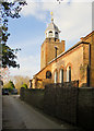
St Peter's, Petersham
Tucked away, off the main Petersham road - which is just as well, given the volume of traffic.
Image: © Stefan Czapski
Taken: 23 Mar 2017
0.06 miles
8
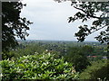
Petersham skyline
View south-west from St Peter's churchyard, in the fourth week of March.
Along the main road there are a number of substantial Georgian houses - the one in the picture being by no means the grandest.
Image: © Stefan Czapski
Taken: 23 Mar 2017
0.06 miles
9
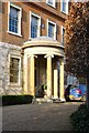
Domed porch, Petersham House
In the Surrey volume of 'The Buildings of England', Nairn and Pevsner suggest an early 19th-century date for this porch, though the façade is reckoned to be a century or so earlier.
Image: © Stefan Czapski
Taken: 24 Mar 2017
0.06 miles
10
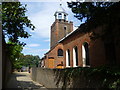
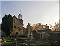
St Peter's Church, Petersham
The attractive little church of St Peter's lies down this lane, just off the very busy Petersham Road. In the pleasant churchyard is the grave of Captain George Vancouver who was born in 1757 and died in 1798. He sailed with Captain Cook to Antarctica and was with him on his last voyage to the Pacific. Captain Vancouver discovered Vancouver Island in British Columbia, which was named after him. The path beyond the church leads to Petersham Meadows.
Image: © Marathon
Taken: 10 Aug 2011
0.07 miles