IMAGES TAKEN NEAR TO
Onslow Road, RICHMOND, TW10 6QF
Introduction
This page details the photographs taken nearby to Onslow Road, TW10 6QF by members of the Geograph project.
The Geograph project started in 2005 with the aim of publishing, organising and preserving representative images for every square kilometre of Great Britain, Ireland and the Isle of Man.

There are currently over 7.5m images from over14,400 individuals and you can help contribute to the project by visiting https://www.geograph.org.uk
Image Map
Images are licensed for reuse under creativecommons.org/licenses/by-sa/2.0
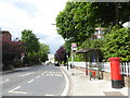
Notes
- Clicking on the map will re-center to the selected point.
- The higher the marker number, the further away the image location is from the centre of the postcode.
Image Listing (57 Images Found)
Images are licensed for reuse under creativecommons.org/licenses/by-sa/2.0
Image
Details
Distance
4
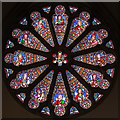
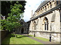
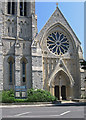
St Matthias, Richmond - Stained glass window
Image: © John Salmon
Taken: 19 Oct 2016
0.06 miles
6
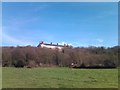
View of the Royal Star and Garter Home from Petersham Meadows
Looking east-northeast.
Image: © Robert Lamb
Taken: 24 Feb 2011
0.06 miles
7
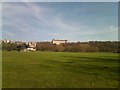
View of the Royal Star and Garter Home from Petersham Meadows #2
Looking east-northeast.
Image: © Robert Lamb
Taken: 24 Feb 2011
0.06 miles
8
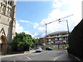
Approaching the junction of Church and Park Roads
Image: © Basher Eyre
Taken: 31 May 2017
0.06 miles
10
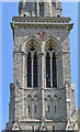
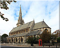
Richmond - St Matthias Church - base of spire
Image: © Dave Bevis
Taken: 21 Jun 2014
0.06 miles