IMAGES TAKEN NEAR TO
Marlborough Road, RICHMOND, TW10 6JR
Introduction
This page details the photographs taken nearby to Marlborough Road, TW10 6JR by members of the Geograph project.
The Geograph project started in 2005 with the aim of publishing, organising and preserving representative images for every square kilometre of Great Britain, Ireland and the Isle of Man.

There are currently over 7.5m images from over14,400 individuals and you can help contribute to the project by visiting https://www.geograph.org.uk
Image Map
Images are licensed for reuse under creativecommons.org/licenses/by-sa/2.0
Notes
- Clicking on the map will re-center to the selected point.
- The higher the marker number, the further away the image location is from the centre of the postcode.
Image Listing (71 Images Found)
Images are licensed for reuse under creativecommons.org/licenses/by-sa/2.0
Image
Details
Distance
1
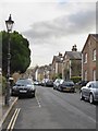
Rosemont Road, Richmond Hill: (2) view north-west
This is a little dead-end street that runs south-east from Friars Stile Road. The houses on the south side are early 'semis', and appear to be all of one build. A string-course at eaves level is a hint that each gable is a classical pediment. Most have a little roundel up in the 'pediment', and all have stone quoins. But the 'Georgian' details are fairly minimal and I'd guess that the row was built after 1830.
Houses on the north side of the street are more varied in style and date.
Image: © Stefan Czapski
Taken: 7 Feb 2017
0.07 miles
2
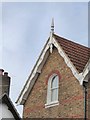
Rosemont Road, Richmond Hill: barge-board detail
Image: © Stefan Czapski
Taken: 7 Feb 2017
0.07 miles
4
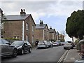
Rosemont Road, Richmond Hill: (1) view south-east
This is a little dead-end street running south-eastwards from Friars Stile Road, stopping just short of Queen's Road.
The houses on the south side are early 'semis', and appear to be all of one build. A string-course at eaves level is enough to hint that the gables are to be read as classical pediments. Most have a little roundel up in the 'pediment', and all have stone quoins. But the 'Georgian' details seem pretty vestigial and I'd guess that the row was built after 1830.
Image: © Stefan Czapski
Taken: 7 Feb 2017
0.07 miles
5
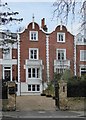
Houses with Dutch gables, Queen's Road, Richmond
There are a number of these handsome buildings along the west side of Queen's Road. Not all retain as much of the original exterior detailing as this pair.
Image: © Stefan Czapski
Taken: 7 Feb 2017
0.07 miles
6
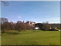
View of the Petersham Hotel and Restaurant and the Royal Star and Garter Home from Petersham Meadows
This is a view of the Petersham Hotel and Restaurant on Nightingale Lane off Petersham Road and the Royal Star and Garter Home on Richmond Hill above and behind it. View looking east from Petersham Meadows.
Image: © Robert Lamb
Taken: 24 Feb 2011
0.10 miles
7
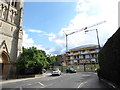
Approaching the junction of Church and Park Roads
Image: © Basher Eyre
Taken: 31 May 2017
0.10 miles
8
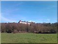
View of the Royal Star and Garter Home from Petersham Meadows
Looking east-northeast.
Image: © Robert Lamb
Taken: 24 Feb 2011
0.11 miles
9
View of the Royal Star and Garter Home from Petersham Meadows #2
Looking east-northeast.
Image: © Robert Lamb
Taken: 24 Feb 2011
0.11 miles
10
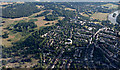
Richmond Hill from the air
The Thames is on the right, the yellow crane is at the Star and Garter building Image
Image: © Thomas Nugent
Taken: 19 Jun 2015
0.11 miles