IMAGES TAKEN NEAR TO
Queens Road, RICHMOND, TW10 6JF
Introduction
This page details the photographs taken nearby to Queens Road, TW10 6JF by members of the Geograph project.
The Geograph project started in 2005 with the aim of publishing, organising and preserving representative images for every square kilometre of Great Britain, Ireland and the Isle of Man.

There are currently over 7.5m images from over14,400 individuals and you can help contribute to the project by visiting https://www.geograph.org.uk
Image Map
Images are licensed for reuse under creativecommons.org/licenses/by-sa/2.0
Notes
- Clicking on the map will re-center to the selected point.
- The higher the marker number, the further away the image location is from the centre of the postcode.
Image Listing (93 Images Found)
Images are licensed for reuse under creativecommons.org/licenses/by-sa/2.0
Image
Details
Distance
1
View of a house on the Richmond University campus from Queen's Road
Looking north-northeast.
Image: © Robert Lamb
Taken: 1 Jul 2012
0.03 miles
2
View of the St Matthias Church, Kings Road from Richmond Park
Looking north-northwest.
Image: © Robert Lamb
Taken: 1 Jul 2012
0.04 miles
3
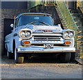
Show me the way to San Jos?: Chevrolet Apache
I don't often submit photos of vehicles to Geograph, on the grounds that they're mobile. But this old Chevy 32 Apache hasn't moved for so long that it seems pretty much a landmark. The San José/California 'license plate' carries the date 1959.
I get the impression that the vehicle is being restored, but it's a slow process.
Image: © Stefan Czapski
Taken: 2 Feb 2012
0.06 miles
4
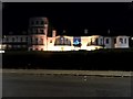
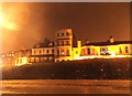
Richmond Gate Hotel
Exclusive hotel by the gate into Richmond Park. It sits opposite the Star and Garter Home. Note the ornate floral fountain in the foreground.
Image: © Colin Smith
Taken: 27 Jul 2007
0.07 miles
5
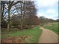
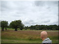
Path skirting Bishop's Lodge Pond
On the perimeter of Richmond Park.
Image: © Christine Johnstone
Taken: 7 Feb 2016
0.08 miles
6

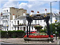
Floral Display on Richmond Hill
Located at the top of Richmond Hill, just outside the Richmond Gate of Richmond Park. Formerly a fountain, dedicated to the Royal Society for the Prevention of Cruelty to Animals.
Image: © Peter Trimming
Taken: 21 Aug 2010
0.08 miles
7
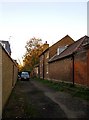
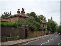
Bishop's Lodge, and the freebord of Richmond Park
When Richmond Park was first enclosed, by King Charles I, the Crown also commandeered a strip of land 16 feet 6 inches wide outside the Park wall. The primary purpose of this strip - the so-called freebord - seems to have been to allow passage along the wall for maintenance purposes. Over the course of centuries much of the freebord has been encroached upon, so that there are now few places where it is still constitutes a public passageway. One such place is here, off Chisholm Road, Richmond, where the freebord gives access to the Park via a pedestrian gate.
The house on the right, built into the Park wall, is known as Bishop's Lodge - because once upon a time a gamekeeper called Bishop lived here.
Image: © Stefan Czapski
Taken: 10 Nov 2010
0.09 miles
8
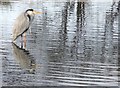
Heron at Bishop's Lodge Pond, Richmond Park
This species, the Grey Heron, Ardea cinerea, is one which has done very well in the London area in recent decades. Within Richmond Park, there is a heronry in Pen Pond Plantation, and herons are an everyday sight - something which was not the case as recently as the early 1970's.
What strikes me about this image is how the bird seems almost camouflaged in these watery surroundings. For another view, taken moments later, see: http://www.geograph.org.uk/photo/2760145
Richmond Park is a National Nature Reserve.
Image: © Stefan Czapski
Taken: 7 Jan 2012
0.09 miles