IMAGES TAKEN NEAR TO
Lewis Road, RICHMOND, TW10 6BT
Introduction
This page details the photographs taken nearby to Lewis Road, TW10 6BT by members of the Geograph project.
The Geograph project started in 2005 with the aim of publishing, organising and preserving representative images for every square kilometre of Great Britain, Ireland and the Isle of Man.

There are currently over 7.5m images from over14,400 individuals and you can help contribute to the project by visiting https://www.geograph.org.uk
Image Map
Images are licensed for reuse under creativecommons.org/licenses/by-sa/2.0
Notes
- Clicking on the map will re-center to the selected point.
- The higher the marker number, the further away the image location is from the centre of the postcode.
Image Listing (503 Images Found)
Images are licensed for reuse under creativecommons.org/licenses/by-sa/2.0
Image
Details
Distance
5
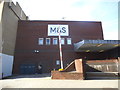
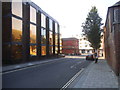
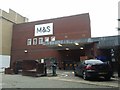
The rear of Marks and Spencer, Red Lion Street
Image: © David Howard
Taken: 9 Apr 2017
0.02 miles
8
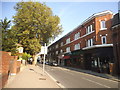
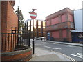
Victoria Place, Richmond
Victoria Place is a wide passageway running between Red Lion Street and George Street. The view here is roughly south-east, towards Red Lion Street.
Many years ago - while at the Bartlett School of Architecture - I did some historical research into the development of central Richmond. As I remember it, this area was the target of a campaign of slum clearance in about the 1870s. Contemporary illustrations showed tarred weather-boarded cottages, with access along narrow passageways. (One such alleyway - Artichoke Walk - survives close by, in name at least).
Just as Victoria Street (SW1) was driven through the slums of Westminster, and New Oxford Street driven through the rookeries of St Giles's, Victoria Place was cut through an impoverished corner of Richmond. The intention in each case was to displace and disperse the flea-bitten, vice-ridden members of the 'lower orders'. Victorian philanthropy . . .
The destructive intent still shows, I think, in Victoria Place. The pedestrian passageway seems wider than it need be, and the place feels semi-inhabited.
Image: © Stefan Czapski
Taken: 24 Dec 2016
0.03 miles