IMAGES TAKEN NEAR TO
The Vineyard, RICHMOND, TW10 6AZ
Introduction
This page details the photographs taken nearby to The Vineyard, TW10 6AZ by members of the Geograph project.
The Geograph project started in 2005 with the aim of publishing, organising and preserving representative images for every square kilometre of Great Britain, Ireland and the Isle of Man.

There are currently over 7.5m images from over14,400 individuals and you can help contribute to the project by visiting https://www.geograph.org.uk
Image Map
Images are licensed for reuse under creativecommons.org/licenses/by-sa/2.0
Notes
- Clicking on the map will re-center to the selected point.
- The higher the marker number, the further away the image location is from the centre of the postcode.
Image Listing (270 Images Found)
Images are licensed for reuse under creativecommons.org/licenses/by-sa/2.0
Image
Details
Distance
1
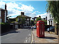
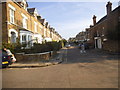
Halford Road, Richmond
Halford Road is a residential road close to the centre of Richmond-upon-Thames.
Image: © Malc McDonald
Taken: 3 Aug 2014
0.03 miles
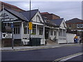
2
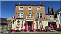
The Dukes Head Inn
Public house and bed and breakfast on corner of The Vineyard and Grosvenor Road.
Image: © James Emmans
Taken: 17 Apr 2021
0.04 miles
3
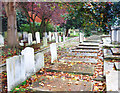
Vineyard Passage Burial Ground
A quiet old cemetery beside a footpath. Established in 1790 and consecrated in 1791, the last burials were in 1874. It is now maintained as a garden of rest.
https://en.wikipedia.org/wiki/Vineyard_Passage_Burial_Ground
Image: © Des Blenkinsopp
Taken: 19 Oct 2017
0.10 miles
4
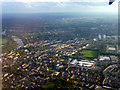
Richmond from the Air
As seen from an incoming flight to Heathrow Airport.
Image: © Christine Matthews
Taken: 25 Sep 2011
0.11 miles
6
Thai Elephant restaurant. Wakefield Road, Richmond
Image: © David Howard
Taken: 16 Aug 2008
0.11 miles
7
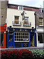
The Victoria Inn
Colourful pub on the lower end of Richmond Hill. It faces onto a small garden above the Petersham Road.
Image: © Colin Smith
Taken: 27 Jul 2007
0.12 miles
8
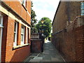
Footpath in Richmond
A footpath in Richmond-upon-Thames.
Image: © Malc McDonald
Taken: 3 Aug 2014
0.13 miles
9
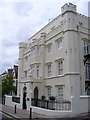
Old Vicarage School, Richmond Hill
Monolithic castellated pile with plastered walls. It is quite different in style from its neighbouring buildings.
Image: © Colin Smith
Taken: 27 Jul 2007
0.13 miles
10
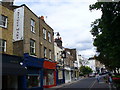
Lower Richmond Hill
This street was formerly known as The Causey or Causeway. This was the former road to Petersham. Shops now occupy many of the old houses, most dating from the 18th Century.
Image: © Colin Smith
Taken: 27 Jul 2007
0.13 miles