IMAGES TAKEN NEAR TO
Ham Farm Road, RICHMOND, TW10 5ND
Introduction
This page details the photographs taken nearby to Ham Farm Road, TW10 5ND by members of the Geograph project.
The Geograph project started in 2005 with the aim of publishing, organising and preserving representative images for every square kilometre of Great Britain, Ireland and the Isle of Man.

There are currently over 7.5m images from over14,400 individuals and you can help contribute to the project by visiting https://www.geograph.org.uk
Image Map
Images are licensed for reuse under creativecommons.org/licenses/by-sa/2.0
Notes
- Clicking on the map will re-center to the selected point.
- The higher the marker number, the further away the image location is from the centre of the postcode.
Image Listing (113 Images Found)
Images are licensed for reuse under creativecommons.org/licenses/by-sa/2.0
Image
Details
Distance
5
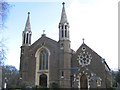
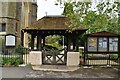
St Andrew's church, Ham Common
Anglican church built in 1830 with later extensions, listed grade II.
Image: © Stephen Craven
Taken: 2 Mar 2006
0.05 miles
6
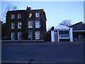
Parkleys, Ham
This is an estate of two storey maisonettes built by the top 1960s architects Span.
Image: © David Howard
Taken: 10 Nov 2014
0.06 miles
9
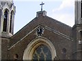
Clock of St Andrew's church, Ham Common
The clock has a single face centrally above the West window.
Image: © Stephen Craven
Taken: 2 Mar 2006
0.07 miles