IMAGES TAKEN NEAR TO
Rothesay Avenue, RICHMOND, TW10 5EA
Introduction
This page details the photographs taken nearby to Rothesay Avenue, TW10 5EA by members of the Geograph project.
The Geograph project started in 2005 with the aim of publishing, organising and preserving representative images for every square kilometre of Great Britain, Ireland and the Isle of Man.

There are currently over 7.5m images from over14,400 individuals and you can help contribute to the project by visiting https://www.geograph.org.uk
Image Map
Images are licensed for reuse under creativecommons.org/licenses/by-sa/2.0
Notes
- Clicking on the map will re-center to the selected point.
- The higher the marker number, the further away the image location is from the centre of the postcode.
Image Listing (36 Images Found)
Images are licensed for reuse under creativecommons.org/licenses/by-sa/2.0
Image
Details
Distance

4
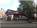
Petrol station on Upper Richmond Road West
Image: © David Howard
Taken: 21 Sep 2018
0.09 miles
5
East Sheen Service Station on Upper Richmond Road
Image: © David Howard
Taken: 13 Aug 2013
0.09 miles
7
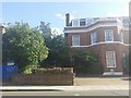
Clifford Avenue, East Sheen
This standard of road passes for the South Circular for nearly all its length from here to Woolwich in stark contrast to the northern equivalent just round the corner over the river.
Image: © David Howard
Taken: 24 May 2014
0.10 miles
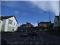
8
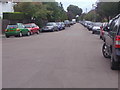
Where the South Circular leaves Upper Richmond Road
Looking along Upper Richmond Road West towards Richmond, and also into a sinking sun in the west.
Image: © Bill Boaden
Taken: 3 Aug 2014
0.10 miles
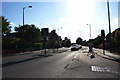
9
Junction in East Sheen
Clifford Avenue joins Upper Richmond Road West.
Image: © Eirian Evans
Taken: 22 Oct 2010
0.11 miles
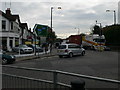
10
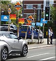
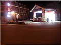
Polling day, May 2018, London SW14
The party posters are displayed along the boundary of a car-wash site, at the junction of Clifford Avenue with Upper Richmond Road West.
Image: © Stefan Czapski
Taken: 3 May 2018
0.11 miles